


I hope everyone had a wonderful Christmas and New Year season! Are you ready for some winter? Tired of the warm temperatures? Ready for SNOW and winter weather?
Back on Dec. 13 I made a post about how stratospheric warming might be getting ready to occur and what implications it might have for us in Georgia for the next several months. As it appears that it has already begun (see the temps here). I'd like to expand on this a little more as we move into the heart of the winter season. Bear with me while I try to explain...
If you follow any of the computer models (which I know most of you don't!), you'll know that right now we have "Model Madness." Each run has a different scenario with no consistency between models or runs. When the models start to get "confused," you can almost bet that big changes are in store. The models are great when the atmosphere is relatively stable, but when major changes start to occur, the models will spit out wildly varying solutions as to what they think will happen down the road. Right now, you can't really trust them with details much further out than four to five days. I was looking at the model verification numbers and for five days (averaged over 30 days) and it is:
- .881 - GFS
- .909 - Euro
- .895 - UK
(see image) - So you can see that even at five days they're only about 88-90 percent accurate and those numbers drop rapidly from there. So details and specifics can be thrown out the window and we have to start looking at long term patterns and pattern changes, in other words, the bigger picture.
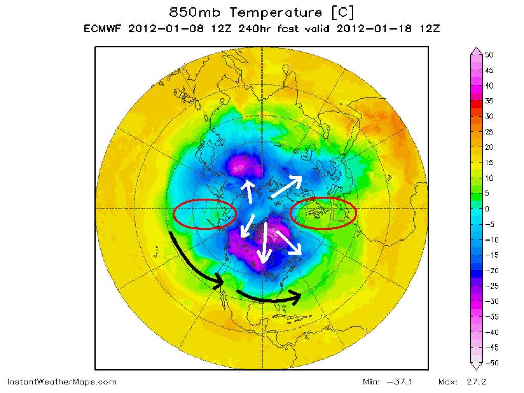
Over the course of the winter so far, we've had a positive AO (Arctic Oscillation) and NAO (North Atlantic Oscillation) while what we need to get cold and snow are negative values for both indices. Favorable positioning of the geopotential height anomalies within the negative phase of the NAO appears to enhance snowfall potential in the eastern U.S. When negative NAO anomalies are positioned such that an area of high pressure is located near Greenland and a polar vortex (area of low pressure) is somewhere near 50°N 50°W, we find an increased potential for winter weather along the U.S. east coast. (see image)
Find out what's happening in Daculawith free, real-time updates from Patch.
- Atmospheric features in a “west-based” negative NAO disrupt the polar jet stream, causing it to buckle and move southward into the Southeast
- Allows cold, Arctic air to be transported south and increases the likelihood of interaction between the northern and southern jet streams
- Jet stream interactions often result in a combining of energy (phasing), which leads to rapid, intense surface cyclogenesis over the southern United States (ie, Storm of The Century 1993).
You can see that we need the pattern to flip in order to take the warmer than average temperatures away and replace those with some cold air. These teleconnection indices are usually very poorly predicted more than a couple of weeks in advance but there are times when other factors come into play and help verify the forecast. There are times when they can rapidly "flip", 1993 was one of those winters (you might remember the Storm of The Century?). And when they do, it can bring bitterly cold polar air into our part of the country. So there are now some hints of change in the teleconnections in that more cold air should become available for us very soon. The big concern is to whether a strong PNA (Pacific/North American Oscillation) regime sets in, which would focus the cold in the west, or a neutral/somewhat negative PNA regime sets up, allowing for more frequent and longer-duration cold farther east. It is encouraging to see the GFS ensembles remaining consistent for the past 5-7 days suggesting this change may well be in the works. What remains to be seen is if the pattern allows the cold air that's projected to build across Western Canada to spill south and affect areas in the west and Plains and leave the east coast warm. But there are suggestions of a weak blocking regime (a good thing) in the longer range which we need in order to get cold air into this part of the country.
But I believe that stratospheric warming holds the key to breaking down the +AO. Right now the models are forecasting a significant warming at all levels of the stratosphere and upper troposphere (which has already started to happen) which will bode well for colder air coming our way. One meteorologist I follow posted this today:
"*** ALERT **** euro ensembles at day 10 thru day 15 now showing MASSIVE stratospheric warming at the 'TOP" of the Atmosphere... (10 mb30mb and 50 mb for you weather geeks) . The SWW (SIGNIFICANT STRATOSPHERIC WARMING) event is now looking increasingly PROBABLE... over 50% chance for the 1st time. Day 12..13...14...15 euro ensemble MEAN shows HUGE amounts of warming and total destruction of super +AO that has been over far Northeast Canada and Greenland since NOV 1"
This warming is VERY significant for our weather here in Georgia. If we get sudden stratospheric warming (SSW) to take place and the +AO goes negative, get ready for winter in a VERY big way. Here's a great link that will help you better understand all of this "weather geek" I'm speaking.
So you can see that there are multiple changes beginning to take place and the signs are falling into place that tell us that winter is far from over. Don't let the mild temperatures that we've experienced over the last 3-4 weeks make you think that winter isn't coming. It's looking like February will be our coldest winter month by far, and we might just experience what it's like to be in the Arctic. We shall see! And if you want to see some seriously cold temperatures, look at this fantasy map.
And by the way... most of the meteorologist have busted on their winter forecast this year and that's an annual occurrence. It's just not practical to forecast weather much more than a month in advance, and even then you're on shaky ground. But it seems that all of them are slowly seeing the changes unfold.
Please remember, whenever you need weather information, please visit us at DaculaWeather.com. You can also get the latest weather information by following us on Twitter and Facebook DaculaWeather.com... Your Window to the Weather