.
Feedback

Isaac Could Bring 2-4" of Rain to Metro Area

Isaac is already a hurricane based on the latest observations.

Isaac Page

While not officially announced by the NHC, latest hurricane hunter reports show Isaac is now of suffcient strength to be Hurricane Isaac and I believe the 10 a.m. update will reflect that.

Isaac is headed toward the mouth of the Mississippi River and the coast of Louisiana with winds of 75 mph and is moving at 7 mph. Isaac's forward motion has slowed considerably since the 5 a.m. update which doesn't bode well for Louisiana at all. Isaac is currently located about 120 miles from the mouth of the Mississippi River, so at this pace, it won't make landfall for another 12 hours or so. 


DISCUSSION AND 48-HOUR OUTLOOK

------------------------------

AT 700 AM CDT...1200 UTC...THE CENTER OF TROPICAL STORM ISAAC WAS LOCATED NEAR LATITUDE 27.8 NORTH...LONGITUDE 88.2 WEST. ISAAC IS MOVING TOWARD THE NORTHWEST NEAR 7 MPH...11 KM/H...AND THIS GENERAL MOTION IS EXPECTED TO CONTINUE FOR THE NEXT DAY OR TWO WITH SOME FLUCTUATIONS IN FORWARD SPEED. ON THE FORECAST TRACK...THE CENTER WILL BE NEAR OR OVER THE LOUISANA COAST TONIGHT OR EARLY WEDNESDAY. MAXIMUM SUSTAINED WINDS ARE NEAR 70 MPH...110 KM/H...WITH HIGHER GUSTS. STRENGTHENING IS FORECAST...AND ISAAC IS LIKELY TO BECOME A HURRICANE LATER TODAY. ADDITIONAL STRENGTHENING IS FORECAST UNTIL THE CENTER MOVES INLAND. TROPICAL-STORM-FORCE WINDS EXTEND OUTWARD UP TO 205 MILES...335 KM FROM THE CENTER.

HAZARDS AFFECTING LAND

----------------------

STORM SURGE...THE COMBINATION OF A STORM SURGE AND THE TIDE WILL CAUSE NORMALLY DRY AREAS NEAR THE COAST TO BE FLOODED BY RISING WATERS. THE WATER COULD REACH THE FOLLOWING DEPTHS ABOVE GROUND IF THE PEAK SURGE OCCURS AT THE TIME OF HIGH TIDE...

* SOUTHEAST LOUISIANA AND MISSISSIPPI...6 TO 12 FT
* ALABAMA...4 TO 8 FT
* SOUTH-CENTRAL LOUISIANA...3 TO 6 FT
* FLORIDA PANHANDLE...3 TO 6 FT
* FLORIDA WEST COAST INCLUDING APALACHEE BAY...1 TO 3 FT

THE DEEPEST WATER WILL OCCUR ALONG THE IMMEDIATE COAST IN AREAS OF ONSHORE WINDS. SURGE-RELATED FLOODING DEPENDS ON THE RELATIVE TIMING OF THE SURGE AND THE TIDAL CYCLE...AND CAN VARY GREATLY OVER SHORT DISTANCES. FOR INFORMATION SPECIFIC TO YOUR AREA...PLEASE SEE PRODUCTS ISSUED BY YOUR LOCAL WEATHER SERVICE OFFICE. NEAR THE COAST...THE SURGE WILL BE ACCOMPANIED BY LARGE AND DANGEROUS WAVES.

WIND...

TROPICAL STORM CONDITIONS ARE EXPECTED TO REACH THE NORTHERN GULF COAST IN THE HURRICANE WARNING AREA THIS MORNING...WITH HURRICANE CONDITIONS EXPECTED BY THIS AFTERNOON. TROPICAL STORM CONDITIONS ARE EXPECTED TO SPREAD NORTHWARD INTO THE FLORIDA BIG BEND AREA AND THE FLORIDA PANHANDLE IN THE TROPICAL STORM WARNING AREA THIS MORNING. TROPICAL STORM CONDITIONS ARE EXPECTED WITHIN THE TROPICAL STORM WARNING AREA IN LOUISIANA BY TONIGHT. TROPICAL STORM CONDITIONS ARE POSSIBLE ON THE COAST OF SOUTHWESTERN LOUISIANA AND THE UPPER TEXAS COAST BY TONIGHT OR EARLY WEDNESDAY.

RAINFALL...

ISAAC IS EXPECTED TO PRODUCE TOTAL RAINFALL AMOUNTS OF 7 TO 14 INCHES...WITH POSSIBLE ISOLATED MAXIMUM AMOUNTS OF 20 INCHES...IN SOUTHEASTERN LOUISIANA...SOUTHERN MISSISSIPPI... SOUTHERN ALABAMA...AND THE EXTREME WESTERN FLORIDA PANHANDLE. THESE RAINS COULD RESULT IN SIGNIFICANT LOWLAND FLOODING. TORNADOES...TORNADOES MAY OCCUR ALONG THE NORTHERN GULF COAST TODAY. SURF...DANGEROUS SURF AND RIP CURRENT CONDITIONS WILL CONTINUE TO AFFECT THE FLORIDA COASTLINE AND PORTIONS OF THE NORTHERN GULF COAST FOR THE NEXT DAY OR SO.

------------------------------------

For us, the main threat is going to be heavy rain. Here's the latest from the Hydrometeorological Prediction Center:

------------------------------------


CONVECTIVE CHANCES SHOULD INCREASE THIS PERIOD FROM NC SOUTHWARD INTO NORTHERN GA..SC AS COLD FRONT SLIPS SLOWLY SOUTHWARD ACROSS THE REGION AND INTERACTS WITH PLUME OF VERY HIGH PWS FEEDING NORTHWARD INTO THE BOUNDARY IN DEEP LAYERED CONFLUENT REGION BETWEEN ISAACS CIRCULATION AND WESTERN PERIPHERY OF WESTERN ATLANTIC RIDGE. WITH PWS EXPECTED TO EXCEED 2.25 INCHES AND MODELS SHOWING INCREASING RIGHT ENTRANCE REGION JET DYNAMICS THAT COULD BE ENHANCED BY OUTFLOW FROM ISAAC...FEEL POTENTIAL FOR SOME SLOW E/W TRAINING BANDS OF HEAVY RAIN WILL BE POSSIBLE..ESPECIALLY FROM NE GA EWD INTO SRN NC..WHERE GENERALLY 1 TO 2 INCH PLUS RAINS WILL BE POSSIBLE WITH ISOLATED HEAVIER AMOUNTS OVER 4 INCHES OR SO GIVEN TROPICAL AIRMASS.

-----------------------------------

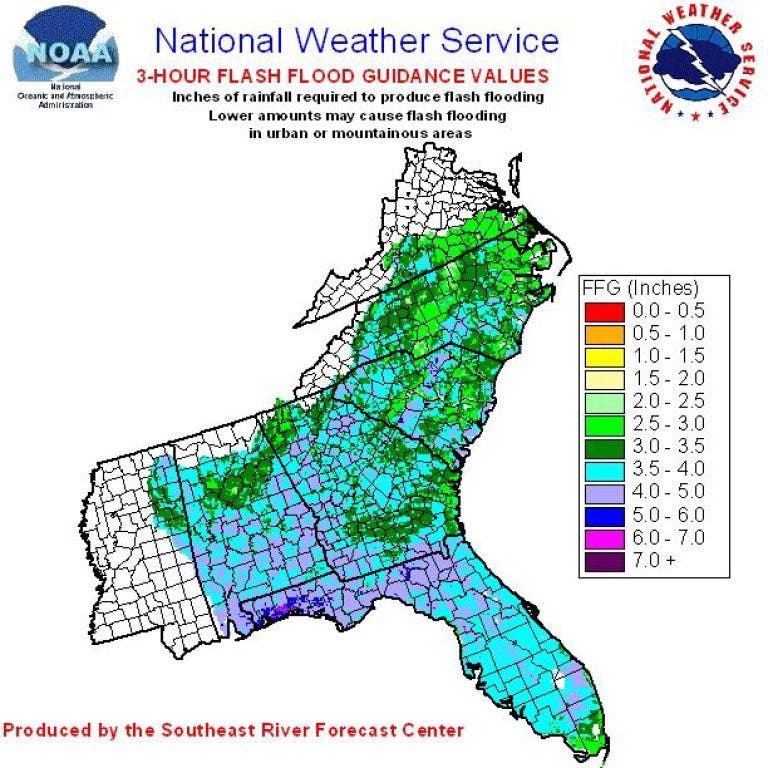
The NWS here in Atlanta is calling for 2-4" of rain between now and Friday with some isolated areas receiving more. The first band of rain is located between Atlanta and Macon and moving north. 2" has already fallen in some of those areas with more to come. Precipital water values are in the 2.2"-2.3" range (notice how thick the air feels?) so when it does rain, it will be a tropical rain and it comes down hard and fast. Ponding on the roadways will be an issue. Our 3 hour flash Flood Guidance shows that we can get about 3" or so before flooding becomes an issue. 

North Georgia Weather August 28, 2012 at 01:22 pm
Time: 12:43:00Z
Coordinates: 28.4667N 86.7833W Acft. Static Air Press: 843.0 mb (~ 24.89 inHg) Acft. Geopotential Hgt: 1,479 meters (~ 4,852 feet) Extrap. Sfc. Press: 999.1 mb (~ 29.50 inHg) D-value: - Flt. Lvl. Wind (30s): From 168° at 81 knots (From the SSE at ~ 93.1 mph) Air Temp: 17.5°C (~ 63.5°F) Dew Pt: 13.4°C (~ 56.1°F) Peak (10s) Flt. Lvl. Wind: 83 knots (~ 95.4 mph) SFMR Peak (10s) Sfc. Wind: 49 knots (~ 56.3 mph) SFMR Rain Rate: 2 mm/hr (~ 0.08 in/hr) (*) Denotes suspect data
North Georgia Weather August 28, 2012 at 01:23 pm
We have a hurricane based on the latest hurricane hunter aircraft. There are two flights currently ongoing. We're tracking the hurricane hunters live right now and will keep you updated.
North Georgia Weather August 28, 2012 at 03:45 pm
Meteorologist are discussing why the NHC didn't upgrade Isaac to a hurricane at the 10am update. The vast majority feel like it should have been upgraded. The thought is that the NHC will wait until the 2pm update to do it and also adjust the forecast track at that point.
We are getting feeder bands of rain in the Atlanta metro area right now and this band might stall out of the area for a while this afternoon as it interacts with a stationary front located over north Georgia. Expect this rain to continue most of the afternoon. Rainfall amounts over Georgia have already exceeded 3" in some locations so please be careful when driving on the streets and roads.
North Georgia Weather August 28, 2012 at 03:46 pm
...ISAAC STILL JUST BELOW HURRICANE STRENGTH AS IT CONTINUES
NORTHWESTWARD... SUMMARY OF 1000 AM CDT...1500 UTC...INFORMATION ----------------------------------------------- LOCATION...28.1N 88.5W ABOUT 80 MI...125 KM SSE OF THE MOUTH OF THE MISSISSIPPI RIVER ABOUT 165 MI...260 KM SE OF NEW ORLEANS LOUISIANA MAXIMUM SUSTAINED WINDS...70 MPH...110 KM/H PRESENT MOVEMENT...NW OR 310 DEGREES AT 10 MPH...17 KM/H MINIMUM CENTRAL PRESSURE...976 MB...28.82 INCHES
North Georgia Weather August 28, 2012 at 04:34 pm
It's official...
HURRICANE ISAAC TROPICAL CYCLONE UPDATE NWS NATIONAL HURRICANE CENTER MIAMI FL AL092012 1120 AM CDT TUE AUG 28 2012 ...RECONNAISSANCE DATA INDICATE ISAAC FINALLY ACHIEVES HURRICANE STATUS... REPORTS FROM AN AIR FORCE RESERVE HURRICANE HUNTER AIRCRAFT INDICATE THAT MAXIMUM WINDS ASSOCIATED WITH ISAAC HAVE INCREASED TO 75 MPH...120 KM/H. ON THIS BASIS...ISAAC IS BEING UPGRADED TO A HURRICANE. SUMMARY OF 1120 AM CDT...1620 UTC...INFORMATION ----------------------------------------------- LOCATION...28.1N 88.6W ABOUT 75 MI...115 KM SSE OF THE MOUTH OF THE MISSISSIPPI RIVER ABOUT 160 MI...250 KM SE OF NEW ORLEANS LOUISIANA MAXIMUM SUSTAINED WINDS...75 MPH...120 KM/H PRESENT MOVEMENT...NW OR 310 DEGREES AT 10 MPH...17 KM/H MINIMUM CENTRAL PRESSURE...975 MB...28.79 INCHES
North Georgia Weather August 28, 2012 at 05:12 pm
Isaac is currently moving parallel to the coast. It's going to be a long night for Louisiana. Reports of flooding already, here's just a sample that are now coming in.
Ocean Springs [Jackson Co, MS] public storm surge at 11:15 AM CDT -- member of the public reported water covering high school parking lot in ocean springs about one half mile inland. it was relayed to NWS New Orleans that it was south of the ocean springs airport. Pascagoula [Jackson Co, MS] emergency mngr reports storm surge at 11:15 AM CDT -- multiple streets in Pascagoula closed due to inundation from storm surge associated with hurricane Isaac. Local Storm Report by NWS LIX: Ocean Springs [Jackson Co, MS] emergency mngr storm report 11:15 AM CDT -- multiple streets in ocean springs closed due to inundation from storm surge associated with hurricane Isaac.
North Georgia Weather August 28, 2012 at 05:55 pm
...SIGNIFICANT WEATHER ADVISORY FOR HEAVY RAIN IN WALTON AND MORGAN
COUNTIES UNTIL 230 PM EDT... AT 129 PM EDT...NATIONAL WEATHER SERVICE DOPPLER RADAR INDICATED SHOWERS WITH HEAVY RAIN FROM MONROE TO MADISON...MOVING NORTH AT 15 MPH. RAINFALL AMOUNTS FROM ABOUT 1.5 INCHES NEAR MONROE TO AROUND 3 INCHES NEAR MADISON HAVE OCCURRED SINCE THIS MORNING. ADDITIONAL RAINFALL AMOUNTS OF AROUND 1 INCH CAN BE EXPECTED OVER WALTON COUNTY AND AROUND ONE HALF INCH OVER MORGAN COUNTY THIS AFTERNOON. THIS INCLUDES THE AREAS AROUND RUTLEDGE...HARD LABOR CREEK STATE PARK... WINDSOR...HERNDONVILLE...YOUTH...EBENEZER... WALNUT GROVE...SOCIAL CIRCLE...LOGANVILLE...JERSEY...BETWEEN... PANNELL...MONROE...BOSTWICK AND NICHOLASVILLE. DRIVERS SHOULD USE CAUTION AS INTENSE RAINFALL WILL REDUCE VISIBILITIES. TEMPORARY STREET FLOODING AND PONDING OF WATER ON ROADWAYS IS LIKELY.
North Georgia Weather August 28, 2012 at 05:57 pm
..SIGNIFICANT WEATHER ADVISORY FOR HEAVY RAIN IN OCONEE...BARROW AND
JACKSON COUNTIES UNTIL 245 PM EDT... AT 141 PM EDT...NATIONAL WEATHER SERVICE DOPPLER RADAR INDICATED SHOWERS WITH HEAVY RAIN MOVING INTO OCONEE...BARROW AND JACKSON COUNTIES...MOVING NORTH AT 15 MPH. RAINFALL AMOUNTS OF AROUND ONE HALF INCH HAVE OCCURRED THIS AFTERNOON. ADDITIONAL RAINFALL AMOUNTS OF AROUND 2 INCHES CAN BE EXPECTED ACROSS OCONEE...BARROW AND JACKSON COUNTIES...
North Georgia Weather August 28, 2012 at 07:54 pm
100 PM CDT TUE AUG 28 2012
...HURRICANE ISAAC MOVING NORTHWESTWARD TOWARD THE MOUTH OF THE MISSISSIPPI RIVER...FLOODING FROM STORM SURGE AND RAINFALL EXPECTED... SUMMARY OF 100 PM CDT...1800 UTC...INFORMATION ---------------------------------------------- LOCATION...28.4N 88.7W ABOUT 55 MI...85 KM SSE OF THE MOUTH OF THE MISSISSIPPI RIVER ABOUT 135 MI...220 KM SE OF NEW ORLEANS LOUISIANA MAXIMUM SUSTAINED WINDS...75 MPH...120 KM/H PRESENT MOVEMENT...NW OR 310 DEGREES AT 10 MPH...17 KM/H MINIMUM CENTRAL PRESSURE...975 MB...28.79 INCHES
North Georgia Weather August 28, 2012 at 09:52 pm
...ISAAC GETTING BETTER ORGANIZED AS IT NEARS SOUTHEASTERN
LOUISIANA...FLOODING FROM STORM SURGE AND RAINFALL EXPECTED... SUMMARY OF 400 PM CDT...2100 UTC...INFORMATION ---------------------------------------------- LOCATION...28.7N 89.2W ABOUT 30 MI...45 KM SSW OF THE MOUTH OF THE MISSISSIPPI RIVER ABOUT 105 MI...170 KM SSE OF NEW ORLEANS LOUISIANA MAXIMUM SUSTAINED WINDS...80 MPH...130 KM/H PRESENT MOVEMENT...NW OR 310 DEGREES AT 8 MPH...13 KM/H MINIMUM CENTRAL PRESSURE...975 MB...28.79 INCHES
North Georgia Weather August 28, 2012 at 10:03 pm
Only moving 8 mph. I would hate to be riding this one out. Even though winds are "only" 80 mph, that would still be hours of hurricane and tropical storm force winds. Currently, hurricane force winds extend out 60 miles and tropical storm force winds extend 185 miles from the center.
NOAA BUOY 42040...LOCATED EAST OF THE MOUTH OF THE MISSISSIPPI RIVER...RECENTLY MEASURED SUSTAINED WINDS OF 63 MPH...100 KM/H...AND A GUST TO 83 MPH. And from this buoy right at the mouth of the Mississippi NDBC Station KMIS 29.296 N 88.842 W 4:35 pm CDT 2135 GMT 08/28/2012 Wind: SSE (150°), 56.9 kt (65 mph) Gust: 92.1 kt (106 mph) Air Temp: 80.6 °F Dew Point: 77.0 °F Visibility: 0.2 nmi
North Georgia Weather August 28, 2012 at 10:04 pm
http://www.ndbc.noaa.gov/station_page.php?station=KMIS
North Georgia Weather August 28, 2012 at 10:17 pm
This is pretty cool... it takes a long time to load so don't watch the screen while it loads... :)
http://www.ssec.wisc.edu/data/1min/index.php?action=view_animation&req_method=nframes_enddate&enddate=20120828&endtime=1803&nframes=200&band=1&res=1&aniwidth=null&aniheight=null Oh... this is pretty cool too http://www.ssec.wisc.edu/~rabin/goes14/loop_srso.html
North Georgia Weather August 29, 2012 at 10:13 am
...ISAAC BEGINNING TO MOVE INLAND IN SOUTHEAST LOUISIANA...DANGEROUS
STORM SURGE AND FLOOD THREAT FROM HEAVY RAINS LIKELY TO CONTINUE THROUGH TODAY AND TONIGHT... SUMMARY OF 400 AM CDT...0900 UTC...INFORMATION ---------------------------------------------- LOCATION...29.2N 90.5W ABOUT 30 MI...50 KM SSE OF HOUMA LOUISIANA ABOUT 60 MI...95 KM SSW OF NEW ORLEANS LOUISIANA MAXIMUM SUSTAINED WINDS...80 MPH...130 KM/H PRESENT MOVEMENT...WNW OR 300 DEGREES AT 8 MPH...13 KM/H MINIMUM CENTRAL PRESSURE...969 MB...28.61 INCHES Isaac has been sitting in roughly the same spot since late yesterday. This is going to be really bad for Louisiana.
North Georgia Weather August 29, 2012 at 12:54 pm
From the National Hurricane Center:
----------------------------------------------- DURING THE PAST HOUR...A SUSTAINED WIND OF 54 MPH WITH A GUST TO 70 MPH WAS REPORTED AT LAKEFRONT AIRPORT IN NEW ORLEANS...A SUSTAINED WIND OF 46 MPH WITH A GUST TO 69 MPH WAS REPORTED AT NEW CANAL STATION IN NEW ORLEANS...AND A SUSTAINED WIND OF 58 MPH WITH A GUST TO 73 MPH WAS REPORTED AT SHELL BEACH LOUISIANA. RAINFALL...ISAAC IS EXPECTED TO PRODUCE TOTAL RAINFALL AMOUNTS OF 7 TO 14 INCHES...WITH POSSIBLE ISOLATED MAXIMUM AMOUNTS OF 20 INCHES...OVER MUCH OF LOUISIANA...SOUTHERN MISSISSIPPI...AND SOUTHWEST ALABAMA THROUGH FRIDAY MORNING. THESE RAINS COULD RESULT IN SIGNIFICANT LOWLAND FLOODING. RAINS ARE EXPECTED TO INCREASE NORTHWARD INTO ARKANSAS ON THURSDAY WITH AMOUNTS OF 3 TO 6 INCHES EXPECTED OVER SOUTHERN ARKANSAS BY FRIDAY MORNING. --------------------------------------- Isaac right now is stationary and has been for the last 3 or 4 hours.
North Georgia Weather August 29, 2012 at 01:03 pm
Very cool wind map of the US
http://hint.fm/wind/
North Georgia Weather August 29, 2012 at 02:20 pm
Still no change....
------------------------ ...ISAAC LASHING SOUTHEASTERN LOUISIANA WITH STRONG SQUALLS... DANGEROUS STORM SURGE AND FLOOD THREAT FROM HEAVY RAINS LIKELY TO CONTINUE THROUGH TODAY AND TONIGHT... SUMMARY OF 800 AM CDT...1300 UTC...INFORMATION ---------------------------------------------- LOCATION...29.5N 90.5W ABOUT 15 MI...20 KM ESE OF HOUMA LOUISIANA ABOUT 40 MI...70 KM SW OF NEW ORLEANS LOUISIANA MAXIMUM SUSTAINED WINDS...80 MPH...130 KM/H PRESENT MOVEMENT...NW OR 310 DEGREES AT 6 MPH...9 KM/H MINIMUM CENTRAL PRESSURE...970 MB...28.64 INCHES
North Georgia Weather August 29, 2012 at 02:42 pm
This from the NWS office this morning regarding our weather today and tomorrow:
------------------------------------------- MAIN PROBLEM IN THE SHORT TERM IS COVERAGE AND TIMING OF SHRA/TSRA. RICH MOISTURE FROM ISAAC CONTINUES TO STREAM EAST FROM THE CENTER OVER THE STATE WITH WEAK FRONTAL ZONE OVER NORTH GA GOING NOWHERE FAST. VERY FAVORABLE WAA (Warm Air Advection) PATTERN IN LOW LEVELS WILL ALLOW FAIRLY WIDESPREAD SHRA WITH SOME TSRA TO DEVELOP BY MIDDAY. RAINFALL COULD BE HEAVY WHERE IT OCCURS BUT ACCUMULATIONS AT ANY ONE SPOT SHOULD REMAIN NO GREATER THAN AN INCH WITH LOCALLY HIGHER AMOUNTS. TOTAL RAINFALL THROUGH FRIDAY SHOULD NOT EXCEED TWO INCHES AT ANY ONE SPOT. MODELS IN PRETTY GOOD AGREEMENT ON COVERAGE TODAY. AFTER FAIRLY QUIET NIGHT WITH LOSS OF INSOLATION...SIMILAR PATTERN EXPECTED THURSDAY WITH RICH MOISTURE AND NEARBY FRONT.
North Georgia Weather August 29, 2012 at 05:22 pm
...ISAAC SOAKING SOUTHEASTERN LOUISIANA AND SOUTHERN MISSISSIPPI
WITH HEAVY RAIN...DANGEROUS COASTAL STORM SURGE AND INLAND FLOOD THREAT EXPECTED THROUGH TONIGHT... SUMMARY OF 1200 PM CDT...1700 UTC...INFORMATION ----------------------------------------------- LOCATION...29.7N 90.8W ABOUT 10 MI...15 KM NW OF HOUMA LOUISIANA ABOUT 45 MI...75 KM WSW OF NEW ORLEANS LOUISIANA MAXIMUM SUSTAINED WINDS...75 MPH...120 KM/H PRESENT MOVEMENT...NW OR 310 DEGREES AT 6 MPH...9 KM/H MINIMUM CENTRAL PRESSURE...973 MB...28.73 INCHES
North Georgia Weather August 29, 2012 at 06:16 pm
Starting to see rainfall amounts over 11" now.
http://www.daculaweather.com/images/2012_08/st_145pm_wed.png
John B August 29, 2012 at 06:35 pm
NGW..please send 2" of rain to Oconee County...much appreciated!
North Georgia Weather August 30, 2012 at 12:24 am
...SLOW-MOVING ISAAC DUMPING HEAVY RAINS AND STILL PRODUCING
A SIGNIFICANT STORM SURGE... SUMMARY OF 700 PM CDT...0000 UTC...INFORMATION ---------------------------------------------- LOCATION...30.1N 91.1W ABOUT 30 MI...50 KM S OF BATON ROUGE LOUISIANA ABOUT 60 MI...95 KM W OF NEW ORLEANS LOUISIANA MAXIMUM SUSTAINED WINDS...60 MPH...90 KM/H PRESENT MOVEMENT...NW OR 315 DEGREES AT 5 MPH...7 KM/H MINIMUM CENTRAL PRESSURE...977 MB...28.85 INCHES ----------------------------- New radar estimates of more than 16"+ http://www.daculaweather.com/images/2012_08/st_735pm_wed.png
Mitch September 5, 2012 at 06:22 pm
So let me get this straight…Hurricane Isaac comes into the US at the Gulf of Mexico near New Orleans. He then proceeds north and does a complete loop across the Midwest. Then, somehow a piece of himself breaks off and moves south down Alabama back to the Gulf of Mexico. Now this piece could become a major storm again and be named Nadine?
I need an explanation, where is our weatherman? Is he still in Cornhusker land?
North Georgia Weather September 6, 2012 at 03:02 am
LOL!!! Yes, I'm still in Cornhusker land and headed back to Atlanta tomorrow!
Isn't weather fun! Yes, Isaac made a big circle around a high pressure center and decided to plop back in the Gulf. And guess what? This is what we have now. TROPICAL DEPRESSION THIRTEEN DISCUSSION NUMBER 1 NWS NATIONAL HURRICANE CENTER MIAMI FL AL132012 500 PM EDT MON SEP 03 2012 THE SMALL LOW PRESSURE SYSTEM LOCATED OVER THE CENTRAL ATLANTIC...WHICH DEVELOPED FROM AN UPPER-LEVEL TROUGH...HAS GRADUALLY ACQUIRED ENOUGH ORGANIZED DEEP CONVECTION TO BE CLASSIFIED AS A TROPICAL DEPRESSION. VISIBLE SATELLITE IMAGERY AND AN EARLIER ASCAT PASS INDICATED THAT THE LOW HAS A WELL-DEFINED CENTER AND RELIABLE WINDS OF AROUND 25 KT. THE INITIAL INTENSITY IS SET A LITTLE HIGHER AT 30 KT SINCE ASCAT HAS A KNOWN LOW BIAS AND BECAUSE THE RESOLUTION OF THE INSTRUMENT LIKELY CAN NOT RESOLVE THE SMALL RADIUS OF MAXIMUM WINDS. THE DEPRESSION IS FORECAST TO MOVE SLOWLY WEST-NORTHWESTWARD AROUND THE SOUTHWESTERN PORTION OF A RIDGE OVER THE EASTERN ATLANTIC DURING THE NEXT 24 HOURS. AFTER THAT TIME...THE CYCLONE IS EXPECTED TO TURN NORTHWARD AS THE WESTERN PORTION OF THE RIDGE ERODES.
R September 6, 2012 at 05:59 am
Well that's political correctness for you, even the "guys" have kids now ...
North Georgia Weather September 6, 2012 at 11:33 am
:-) Son of Isaac
Jim Stephenson September 12, 2012 at 02:07 am
NGW, this has nothing to do with your post, but I wanted to share that I just took the Storm Spotters class from the NWS, presented be the Gwinnett County EMS. I found this class very interesting and informative, and hope to be able to help with weather spotting!
North Georgia Weather September 12, 2012 at 10:35 am
That's great Jim! When I took my class, I had to go over to Winder, there was nothing around here in this area. I think Kristi took the class also!
I'm also a part of the Spotter Network. http://www.spotternetwork.org/ Their training is a little more rigorous than the NWS class and very thorough. If you liked the NWS training, I think you'll like this too.

Newsletter & Alerts

Get the best stories each day and important breaking news

Subscribe

Not from Dacula Patch? Find your Local Patch »

Note Article
Just a short thought to get the word out quickly about anything in your neighborhood.
Share something with your neighbors. Write a new post... What's up? Make an announcement, speak your mind, or sell something
Kristi Reed (Editor) June 18, 2013 at 07:42 am
Indeed. I hope everyone will take some time to explore the site, check out the features and thenRead More look for the feedback button on the right side of the page. Click on that to let Patch know your thoughts on the new platform.
Dave June 18, 2013 at 08:46 am
It's pretty but I found lots of bugs. I'm sure these will be worked out over time. It's new soRead More we'll give it some time.
Kristi Reed (Editor) June 18, 2013 at 08:54 am
Yes, unfortunately I've found a lot too but the engineers are working on it and hopefully we'll haveRead More a much more stable site shortly. In the meantime, please report any issues using the feedback tab on the right side of the page. Thanks!
Robbi McCaig June 12, 2013 at 12:08 pm
"There are people in all levels of government office who would like nothing more than to beRead More able to conduct all the public business out of public view" The problem is, who's going to stop them? Certainly--no one from this justice department who is complicit in multiple overreaches and coverups.
Tammy Osier June 12, 2013 at 12:41 pm
I wrote this on another post but it so applies here and is worth repeating: James Madison wrote inRead More the federalist paper (no. 51) concerning the separation of powers and need for limited government , "“ It may be a reflection on human nature, that such devices should be necessary to control the abuses of government. But what is government itself, but the greatest of all reflections on human nature? If men were angels, no government would be necessary. If angels were to govern men, neither external nor internal controls on government would be necessary. In framing a government which is to be administered by men over men, the great difficulty lies in this: you must first enable the government to control the governed; and in the next place oblige it to control itself. A dependence on the people is, no doubt, the primary control on the government……” We need to have a "Madison moment"...
Tammy Osier June 12, 2013 at 12:41 pm
I remember when I opened up the news to see that Holder was going to investigate Holder. Ha! What'sRead More scary is that there are some who think that's just fine?
Linda Davis June 18, 2013 at 08:48 pm
Thanks Erin, we will know by the 30th of June who won the Bammy Award for my category. Keep meRead More lifted up in prayer. Linda