We kicked off meteorological winter on December 1st and in my child like brain, it's time to see some snow! I suppose if I lived up north it might get old, but I don't, I love to see falling snow. Some of my best childhood memories involve playing in the snow. We use to block off a road (much to the chagrin of the mailman) with a big snow wall and use it as our sled course. We'd be out for hours and hours, never getting cold and not wanting to stop even if we did. My beagle would be totally covered in snow balls and ice and even he would keep going despite the extra 10 pounds of weight attached to his body.
So yes... I guess I live in the wrong place. I'd be better off in the mountains of NC/TN I suppose, or at least someplace that is more conducive to snowfall. But since that isn't happening anytime soon, I'll have to live my winter life through those that do have snow.
All of this kind of leads to my reason for writing this blog post. No, it's going going to snow any time soon here but there are some changes that appear to be coming that may bring enough cold air to at least place us in a position for the possibility of winter precipitation.
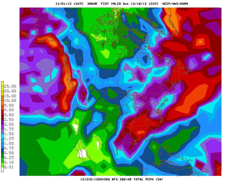
My buddy Robert Gamble at WXSouth.com has this to say about the upcoming pattern change:
"The GFS model brings the westerlies south around week 2 in December but it goes more into a more hardcore Winter mode with strong blocking in the northern Latitudes and strong ridging where there is currently the Alaskan Vortex, beginning in as little as a week. I think this is overdoing things, as far as super strong PNA ridging out west, especially later on, but if it’s right, then Winter will come ushering in quickly just past 10 days for a big chunk of the country. One other thing that could happen as far as the Southeast is concerned, some members of GFS (many in fact) have a Southeast ridge and strong positive tilt trough, which basically is just southwest flow aloft over the Southeast and a strong baroclinic boundary. This would be great news to deliver rain fall, but would keep the coldest air away from the Southeast for a while. But at the same time, extrapolating from GFS still leads me to believe that things at the top of the continent will cause a collapse, in tandem with negative NAO, so we won’t escape a cold pattern much longer, even if it’s delayed thanks to a positive tilt trough. It’s going to be a headache forecasting things beyond 7 days until we actually get into the new pattern".
Right now, the GFS is showing some serious rainfall over the southeast in two weeks, and even though 4-5" might be overdone, it also may be correct. Needless to say, changes are in the works for our weather as we approach the Winter Solstice, which this year occurs on Friday, December 21st at 6:12 am.
And if you're wondering where the cold air is, here are a few temps from yesterday morning from Alaska:
Chicken Co-op: -52F
Tok CWOP: -50F
Dawson, YT: -46F
Eagle Co-op: -44F
Northway: -42F
Coal Creek RAWS: -42F
The low of -30F through 9am at the Fairbanks Airport is the lowest of the season thus far. Again, I have a page with about 8 different weather stations from Canada and Alaska. 7 of these stations also have a webcam, so you can virtually travel to some of the coldest places in the northern hemisphere from the warm comfort of your living room. And while you're traveling to these remote places, please visit the Mount Washington Observatory in New Hampshire. It's actually a pretty balmy 27ºF right now, but in a few days it will all change. I've added images from 4 of their webcams so you can see what it's like (although the snow and clouds make it difficult to see much of anything right now).
Please remember, whenever you need weather information, please visit us at the new and improved DaculaWeather.com. You can also get the latest weather information by following us on Twitter and Facebook
DaculaWeather.com... Your Window to the Weather
YUM saith the Furby.
GIVEN THIS CONTINUED MODEL INCONSISTENCY -- BOTH BETWEEN THE VARIOUS MODELS AS WELL AS WITHIN THE MODELS FROM RUN-TO-RUN...THE OBVIOUS UNPREDICTABILITY OF THE PATTERN DOES NOT LEND ITSELF TO CONFIDENT CONVECTIVE FORECASTS...PARTICULARLY BEYOND DAY 5 /SUN. 12-9/.
"It’s best to take things one at a time in this flow and not make too many hasty calls beyond 7 days as LOTS keeps changing on the models. If you haven’t noticed yet, both big globals keep adjusting the 7 to 10 day outlooks with ridges shifting positions by huge distances. This of course, means a world of difference in actual weather at the surface. We’ll take a look at this again after 12z runs. Overall, the country is turning colder, but the Southeast will be more under southwest flow, with gradually decreasing temps the further north you get."
AND FINALLY AS WE CONTINUE WITH A MORE ACTIVE PATTERN NEXT WEEK... SHOULD SEE MORE STEADY STREAM OF SYSTEMS MOVING THROUGH THE SOUTHERN STATES EVERY FEW DAYS. DEFINITELY GIVES US WEATHER WEENIES SOMETHING TO LOOK AT. SNELSON
1. The AO is below -3.000 for the 3rd consecutive day. 2. The ensemble guidance past day 10 increasingly favors the kind of pattern change that would be indicated with the slow retrogression of the persistent blocking currently underway, even with a PNA- pattern. 3. The latter frames of the 12/10/2012 12z GFS ensembles show widespread cold anomalies across much of the U.S. and southern Canada. The week 4 anomaly on the 12/8 and 12/9 runs of the CFSv2 are similar to the closing frames of the GFS ensembles. 4. There is still no indication of any outbreaks of severe cold. I suspect such outbreaks are not very likely this month. 5. The ENSO Region 3.4 anomaly has dipped to -0.1°C for the week centered around 12/5. However, the dramatic drop in the SOI (-48.84 today) suggests that this region will likely warm in the near-term. Such a development could enhance prospects for a stormy close to December as the subtropical jet becomes more active. This possibility could coincide with a colder pattern, especially if the GFS ensembles are reasonably accurate.
http://www.daculaweather.com/4_georgia_white_christmas.php
Here's a quote from Robert Gamble at WXSouth.com: "One very unusual aspect I see on the operational's (not the ensembles) is the short wave lengths on some systems. We didn't see this at all last year. This too, means you can’t make much of a specific forecast too far in advance, and it also is a sign of a blocking up Greenland/Canada region, which also didn’t occur last year." Without the blocking, the cold air remains in higher latitudes. With the blocking, the cold air is displaced south since it can't move west to east, it instead takes a dive our direction.
Our next big system will be early next week. The GFS is showing a very vigorous upper level low that will sweep our area on Monday/Tuesday with a strong cold front.
"S-N-O-W ? ? ? New run of European Model is falling in line with the GFS model, showing a powerful storm cutting through the Southeast early to mid Next week. GFS run had this a couple of days now, and European run has shifted it's track from Chicago, to the Ohio Valley and now through the Southeast, as it recognizes blocking in eastern Canada, which will force the storm closer to the Southeast. By Tuesday night it shows the storm center in southern Alabama then re-developing off the Georgia Coast by Wednesday morning. Temperatures aloft and the surface will be hard to forecast and are very close to Snow Threshold across northern Arkansas, most of Tennessee, northern Mississippi, northern Alabama, north Georgia, Upstate SC and much of NC into Va. We have plenty of time to watch this potential Winter Storm."
"Now what are the REAL chances this comes to fruition? Probably won’t be exactly like this, as I’ve never seen a storm modeled exactly right from 7 to 8 days away, but in general (and that’s all I can say now) is that the chances of a Southeastern Third of the US type of storm is very high. But I also wouldn’t be surprised to see a little bit of lifting more north with some future runs. There will no doubt be some major back and forth swings, where runs lose it, bring it back, change the track etc." So stay tuned... things are looking VERY interesting for next week! And on a side note and a cheap plug for my buddy, if you're a real weather weenie, try out a paid subscription to WXSouth.com for a month or so. It's only $9.95/month and Robert is one of the best southeast winter forecasters I've found. You'll really learn a lot and stay informed at the same time. Otherwise... I'll keep you informed right here. There will be lots to talk about as the week progresses.
"12z GFS continues to pound the idea of pattern change, and kicking it off with a potential winter storm for the SE/Mid Atlantic region. This previous wave then falls back into this storm and forms a full-fledged 50/50 low. Meanwhile in the pacific, as hinted at on last night's 0z run, a UL drops well south and cuts off from the main flow looking beyond D+10, firing up the STJ (recent tanking of the SOI portends to this idea). This effectively destroys the persistent +EPO/-PNA setup we've been dealing with the past few weeks. If this comes to pass, expect a more persistent cold pattern with arctic fronts finally making their way down to our neck of the woods. In addition, the active STJ will increase our threats for winter weather. The first threat we've been seeing with the "kick-off" system a week from now is coming in before any real cold is established so it's going to be a borderline event that's going to hinge on dynamic effects, if it even comes to pass at all. After this storm, cold air should arrive in more abundance, along with a more stormier pattern as the Pacific may finally be on our side."
4 RUNS OF GFS. SFC AND UPPER LOW STILL PROGGED TO GO NORTH OF CWA. ECMWF DOES HAVE FURTHER SOUTH TRACK AND UPPER LOW COULD CLOSE OFF BEFORE REACHING GA IN 12Z RUN. WILL NEED TO CONTINUE TO WATCH THIS. INITIAL WAVE MOVING THROUGH THE MIDWEST LATE THIS WEEK SHOULD KEEP ANY COLD AIR MASS AT SFC WELL TO THE NORTH OF THIS PART OF THE COUNTRY. STAY TUNED.
It now appears that our first brush with winter precipitation will be right around Christmas. More details to come in a separate blog post.