Health & Fitness
Polar Vortex Beginning to Shift?
Stratospheric warming may hold the key for our winter weather.


There have been some interesting weather developments recently that may potentially bring a more winter-like pattern to the southeast in the next few weeks. Stratospheric warming is beginning to occur which has significant implications on the blocking patterns that setup during the winter months. This latest quote is from a very well respected meteorologist from Houston Texas, Larry Cosgrove.
EXTENDED PERIOD FORECAST
(Between Day 11 And Day 15)
"Life After The Storm": Why The Circumpolar Vortex Bodes Ill For Those Hating The Cold!
NOAA/SSD/IMS
NRL
WEATHERAmerica
Environment Canada
Penn State University E-Wall
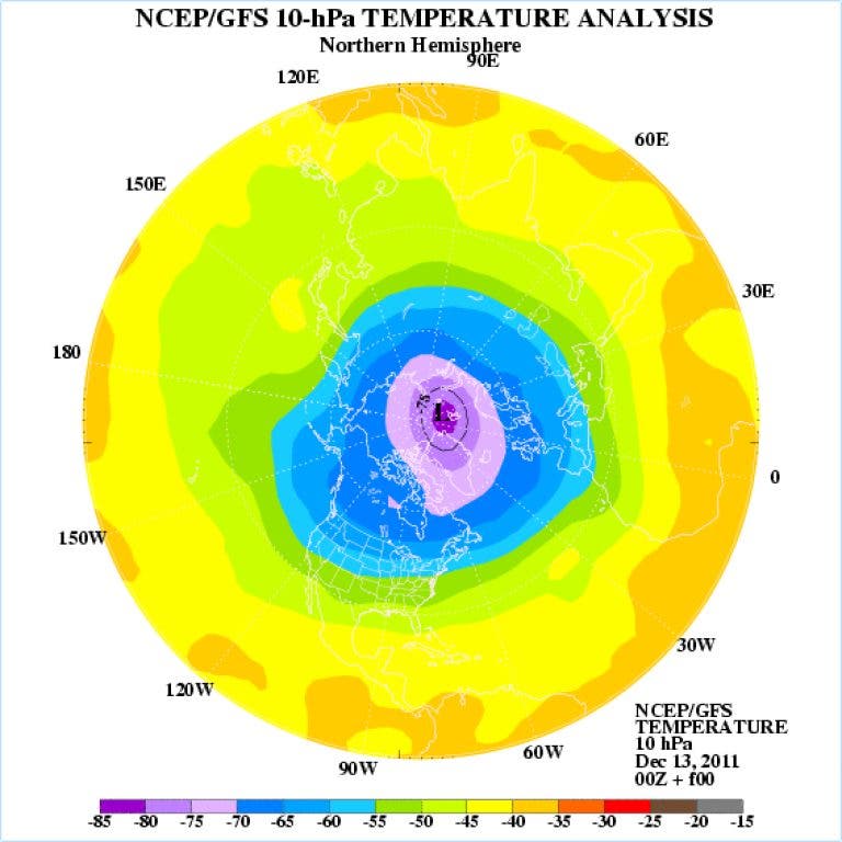
There are three key features which may or may not impact the longer term outlook. One, of course, is the S Florida/Bahamas heat ridge that is forecast to flatten/weaken somewhat. Another is the potential major winter storm (aided by inflow from the Pacific Ocean subtropical jet stream) slated to affect much of the nation through December 21 (see attached image). But the big player in the system is the cAk motherlode, also known as the Circumpolar Vortex. Many of the numerical models have been suggesting that this feature, until recently stuck near the North Pole, may drift and expand southeastward with a core position near Hudson Bay.
The recent tendency for full-phase, massive bombogenesis cases in the northern Atlantic Ocean might be explained by this drift, which is essentially a case of a positive phase of the Arctic Oscillation gone insane. So much cold air in a cluster starts to "drip" over the pole into North America. In time breakaway pieces from the gyre drag the core circulation so far south that pure cAk values are able to occupy locations in the U.S. This type of event has happened twice in recent history: December 1976/January 1977 and December 1983. Once established, the dome can last as much as 45 days, destroying temperature records in the process. It is too early to suggest that this scenario might verify, but recent stratospheric temperature anomaly forecasts are turning very warm over Canada in the 11 - 15 day period. If so, southward displacement of the harshest of air mass may be enabled in the days just before Christmas.
Things could get very interesting beginning around Christmas and shortly thereafter as we head into the new year. No promises just yet but if you like winter weather, the outlook may be improving!
Find out what's happening in Daculawith free, real-time updates from Patch.
Please remember, whenever you need weather information, please visit us at DaculaWeather.com. You can also get the latest weather information by following us on Twitter and Facebook DaculaWeather.com... Your Window to the Weather