

If you've been following the weather (of course you have...!) you have heard of the potential storm Sandy that will be forming in the Caribbean over the next 3-5 days along with the possible impact for the eastern US. But what you probably haven't heard is what several of the models are now suggesting may happen after Sandy forms. Meteorologist Allan Hoffman (who also graciously provides many of the computer model graphics on DaculaWeather.com) specializes in tropical systems and has made a new post on his blog that outlines what could happen as Sandy evolves early next week, and here are a few of his highlights.
The entire story can be read here with many more details. Italics and bold are mine.
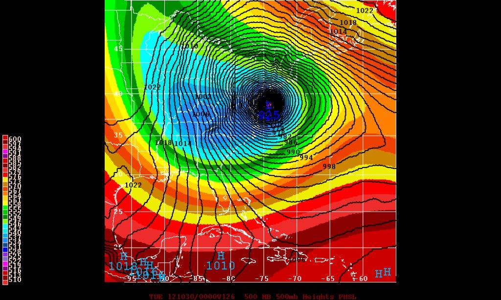
- A landfalling strong tropical/subtropical system into southern New Jersey next Tuesday 10/30. The model actually has the storm at category 3 intensity east of Hatteras Monday evening. Likely overdone, but literally what the model has. The Canadian is around 960mb.
- This would bring hurricane force winds likely from the Tidewater to Cape Cod including Philadelphia, New York City, perhaps Washington DC, and Boston and all the major cities in between.
- With the storm moving inland and maintaining strong intensity due to the trough phasing, we would see destructive winds all over the inland sections of the Northeast US.
- With the trough phasing we would see significant cold air on the backside of the storm with the model showing 4-8 inches of snow over western ND, southwest PA, eastern WV, northern Virginia, including a couple inches of snow near Washington DC and a dusting as far south as southern Virginia. In fact taken literally at 18z on Tuesday 10/30 it is 34 and snowing at Washington DC and 35 and snowing at Richmond, while Boston is 64 with hurricane conditions.
- Frost/Freezes would penetrate well into the southeast early next week.
Find out what's happening in Daculawith free, real-time updates from Patch.
This would obviously be one of the most epic/high impact storm events in recent memory and maybe all time as far as just pure weather effects across highly populated areas. So the question is what is going to cause this to happen and is it a realistic scenario? Find out here...
We'll keep you updated as this system develops.
Find out what's happening in Daculawith free, real-time updates from Patch.
Please remember, whenever you need weather information, please visit us at the new and improved DaculaWeather.com. You can also get the latest weather information by following us on Twitter and Facebook DaculaWeather.com... Your Window to the Weather