.
Feedback

Rain for the Weekend?

Will we have a wet weekend?

It looks like we're finally going to get a decent rainfall over the next several days. 

Saturday will see an increase in cloud cover as the next system approaches, but the rain should remain to our west. Sunday will be a different story with an abundant flow of moisture at all levels kicking off showers in advance of the tail end of a cold front that will run from the Great Lakes to the Gulf coast. 

Monday will bring a chance of thundershowers as the front approaches with a weak vortex max approaching late Sunday night into Monday. This upper air spin will provide some twist to the atmosphere on top of some low level shear, and could cause a few thunderstorms to pop-up, but nothing severe.

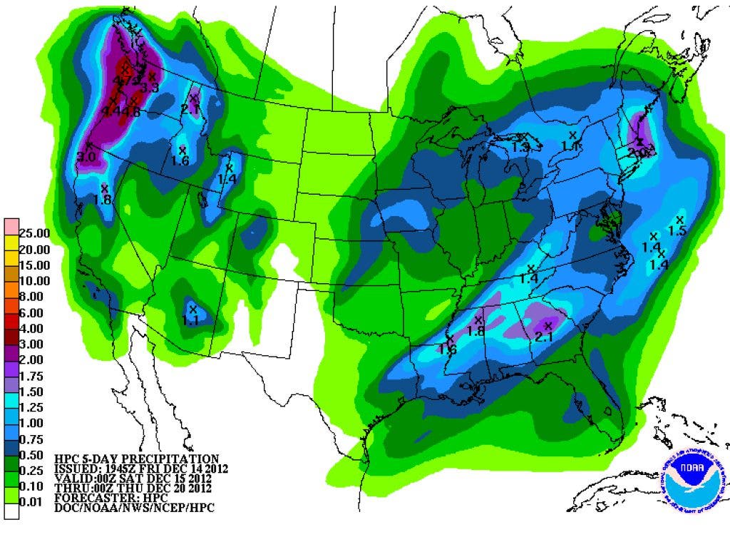
The Hydrometeorological Prediction Center is calling for several inches of rainfall over the next five days, which would go a long way toward reducing the drought in our area and over much of Georgia. Here is a link to the drought maps, currently about 71 percent of the nation is in some stage of drought. If you'll scroll down to the last map, you'll see that some western metro counties would need 12-15 inches of rain to break the drought. 

Forecast temperatures will run about five degrees above normal tonight, five to eight degrees above normal on Saturday, and 12-17 degrees above normal on Saturday night.

Please remember, whenever you need weather information, please visit us at the new and improved DaculaWeather.com. You can also get the latest weather information by following us on Twitter and Facebook 
DaculaWeather.com... Your Window to the Weather

North Georgia Weather December 15, 2012 at 12:02 pm
Each model run has been increasing the strength of the cold front coming through on Monday. Not only has the Atlanta office talked about it, the Birmingham office wrote about it this morning:
IN OUR BUSINESS WE LIKE TO SEE MODELS CONVERGING ON SOLUTIONS. THIS HELPS TO INCREASE CONFIDENCE IN THE FORECAST. UNFORTUNATELY IN THIS CASE...IT MAY NOT BE THE BEST NEWS FOR THOSE OF US IN CENTRAL ALABAMA BY THE END OF THIS WEEKEND. THE MAIN FOCUS OF THIS FORECAST WILL BE OVER THE NEXT 48 HOURS AS WE ARE LOOKING MORE AND MORE LIKE THIS NEXT SYSTEM COULD BE A SEVERE WEATHER MAKER. The SPC has placed parts of Georgia in a Slight Risk for severe weather on Sunday and our area will be re-evaluated for the next outlook. Day 2 (Sunday) - http://www.daculaweather.com/4_spc_day2_outlook.php Day 3 (Monday) - http://www.daculaweather.com/4_spc_day3_outlook.php ACTIVITY WILL BE EMBEDDED WITHIN STRONG DEEP LAYER WIND PROFILES ...WITH LARGE HODOGRAPHS AND STRONG VERTICAL SHEAR SUPPORTIVE OF ORGANIZED STORMS INCLUDING BOWING STRUCTURES AND SUPERCELLS. WILL INTRODUCE A 5% SEVERE COVERAGE AREA AT THIS TIME DUE TO POTENTIAL LIMITING FACTORS IMPOSED BY THE EXPECTED MARGINAL THERMODYNAMIC ENVIRONMENT. HOWEVER...AREA WILL BE RE-EVALUATED FOR A POSSIBLE SLIGHT RISK ON THE DAY 2 UPDATE.
North Georgia Weather December 15, 2012 at 12:10 pm
From the Birmingham office, they seem to be very concerned.
BY SUNDAY NIGHT THOUGH...AS THE THIRD TROUGH APPROACHES THE MID-MISSISSIPPI VALLEY...EVEN THOUGH ITS NOT EXTREMELY AMPLIFIED...THE AXIS OF THIS TROUGH TILTS FROM NEUTRAL TO NEGATIVE. THIS IS LIKELY TO ENHANCE THE SEVERE WEATHER THREAT IN A COUPLE OF WAYS. IT WILL HELP IN THE DEVELOPMENT OF A SURFACE LOW THAT WILL TRACK JUST OFF TO OUR NORTH...AS WELL AS CREATE A LOW LEVEL JET AROUND THE MIDNIGHT HOUR SUNDAY NIGHT THAT IS EXPECTED TO INTENSIFY AS WE APPROACH SUNRISE MONDAY MORNING. THIS 35-40 KT LLJ...COUPLED WITH WELL-PLACED UPPER LEVEL DIVERGENCE BECAUSE OF A 120-140 KT 200-300MB JET...COULD PROVIDE THE NECESSARY SYNOPTIC CONDITIONS FOR SEVERE WEATHER TO DEVELOP ACROSS MISSISSIPPI AND ALABAMA. HEDGING FOR THE EXACT TIME THAT THIS LLJ DEVELOPS...THE MAIN TIMEFRAME WE WILL BE FOCUSING ON WILL BE 10PM SUNDAY NIGHT THROUGH THE NOON HOUR ON MONDAY. ... continued
North Georgia Weather December 15, 2012 at 12:10 pm
... continued
IN ADDITION TO THE SEVERE WEATHER THREAT OF DAMAGING STRAIGHT LINE WINDS AND POSSIBLE TORNADO DEVELOPMENT...EXCESSIVE RAINFALL COULD BECOME AN ISSUE AS WELL. RAINS DURING THE DAY SUNDAY COULD CREATE A SATURATED GROUND...AND ANY AREAS THAT SEE PROLONGED RAINFALL SUNDAY NIGHT COULD EXPERIENCE LOCALIZED FLASH FLOODING. WE WILL HIGHLIGHT ALL THREE OF THESE THREATS IN THE HAZARDOUS WEATHER OUTLOOK THIS MORNING...WITH AN INCREASED CONCERN FOR TORNADO DEVELOPMENT SUNDAY NIGHT FOR MOST OF CENTRAL ALABAMA...AND MONDAY MORNING FOR AREAS EAST OF INTERSTATE 65. WITH THE FACT THAT THIS THREAT WILL BE DURING THE OVERNIGHT HOURS SUNDAY NIGHT...THIS IS A GOOD TIME TO TAKE A FEW MINUTES AND MAKE SURE YOUR NOAA WEATHER RADIO IS IN GOOD WORKING ORDER AND HAS A FRESH BATTERY BACKUP.
North Georgia Weather December 15, 2012 at 12:12 pm
Keep in mind that the timing of this threat for us would be early morning Monday through the afternoon hours.
North Georgia Weather December 16, 2012 at 07:35 pm
.HYDROLOGY...
RAINFALL OF 1-2 INCHES IS STILL IN THE CARDS. WITH PREVIOUS DRY CONDITIONS THIS RAINFALL IS WELL NEEDED AND NO SIGNIFICANT FLOODING IS EXPECTED.
Tommy Hunter December 16, 2012 at 10:40 pm
We need some light flooding!!
North Georgia Weather December 17, 2012 at 02:04 am
You've got that right! And we have another great chance on Thursday.
Kristi Reed (Editor) December 17, 2012 at 02:05 pm
My rain gauge shows 1.4" here in Dacula so far.
North Georgia Weather December 17, 2012 at 02:06 pm
Excellent write by Donald Sutherland... I had to share. It is a little geeky but read through the geek part...
Part 1 - Pattern Change Now Evolving as Panic of December '12 Rises... The storm that brought record daily snowfall to Minneapolis-St. Paul commenced a sequence of events that is leading to a pattern change. That sequence of events will likely include several systems (one underway and one or two others in coming days) that will be noted more for wet than white in the East. Afterward, the last 10-14 days (14 days for the Plains States and 10 days for the East Coast) could see generally cooler than normal weather. The rising panic that Winter 2012-13 is becoming a repeat of the non-Winter of 2011-12 has resulted for a large gap between the actual pattern change that is now imminent and expectations. The pattern change was likely to be slow with a fairly lengthy transition before sustained colder weather set in. Given the combination of an EPO+, PNA-, and persistent Arctic warmth, severe cold was not very likely for much or all of December. Expectations were for prolonged and deep cold to set in with the potential for excessive snows. That gap was unsustainable, hence the rising panic. ... continued
North Georgia Weather December 17, 2012 at 02:06 pm
... continued -
If one steps back to take a look at the non-Winter of 2011-12, one finds: 1. A powerful AO+ regime predominated in December. 2. The long-range guidance and analog cases were unrelenting with their warm idea. 3. The subtropical jet was quiet. To date, one finds: 1. A persistent AO- regime. The AO has now been negative for 22 consecutive days. It is likely to remain predominantly negative for the remainder of the month as per the ensemble guidance and also historic cases. Notable long-lived blocks that developed in the 11/20-12/10 timeframe have typically been long-lived. Put another way, the blockiness that was present in mid-Autumn reasserted itself during the winter. Recent examples include the blocking regimes of 2009-10 and 2010-11. The following severe blocking episodes (minimum AO value of -3.000 or below) began in late November/early December (11/20-12/10) following a blocky October (monthly AO of -025 or below): December 7, 1966-January 11, 1967: 36 days December 7, 1981-January 12, 1982: 37 days November 29, 2009-January 15, 2010: 48 days December 3, 2010-January 15, 2011: 44 days All four of those cases saw the January AO average < 0. KU snowstorms occurred during the winter in 1966-67, 2009-10, and 2010-11. A KU snowstorm occurred during the spring in 1981-82,
North Georgia Weather December 17, 2012 at 02:07 pm
... continued
2. The long-range guidance has been anything like last winter. In fact, the latest CFSv2 guidance has trended toward widespread cold to begin January and a generally cold month across much of North America. With the PNA having been negative for 41 consecutive days, both historic cases and some ensemble members suggest that it could go positive near or during January. Once that happens, the dam that has kept some of the coldest air bottled up in Alaska and westward could break and a genuine prospect of at least an outbreak of severe cold could develop. Below are the latest CFSv2 weekly (weeks 3 and 4) and monthly (January 2013) forecasts: http://img.photobucket.com/albums/v327/donsutherland1/CFSv212152012weekly.jpg http://img.photobucket.com/albums/v327/donsutherland1/CFSv212162012Monthly.jpg 3. The SOI has recently gone negative. December 10-12 had values below -40. The 30-day moving average has gone negative and the 90-day moving average is near 0. Often such developments suggest a stronger subtropical jet. Hence, there is a possibility that the closing 10 days of December and perhaps the opening 10 days of January could be stormy. ... continued
North Georgia Weather December 17, 2012 at 02:08 pm
and finally....
In sum, the gradual pattern change is unfolding. At first, the cold will be a little more impressive than seasonal cold. Storminess could increase as well. The possibility of an outbreak of severe cold could increase after the start of January, as the PNA heads to more neutral values,and especially if it goes positive. All said, even as the first two weeks of December have been sufficiently warm to rekindle nightmares of the non-Winter of 2011-12, there are big differences that argue against a repeat.

Newsletter & Alerts

Get the best stories each day and important breaking news

Subscribe

Not from Dacula Patch? Find your Local Patch »

Note Article
Just a short thought to get the word out quickly about anything in your neighborhood.
Share something with your neighbors. Write a new post... What's up? Make an announcement, speak your mind, or sell something
Kristi Reed (Editor) June 19, 2013 at 10:12 am
That is odd. I wonder if a sign is missing (or maybe more than one sign). Maybe Gwinnett DOT has anRead More answer: http://www.gwinnettcounty.com/portal/gwinnett/Departments/Transportation
Kristi Reed (Editor) June 19, 2013 at 10:13 am
OK - so the link doesn't work when you paste it into a comment. I see what you meant earlier.
North Georgia Weather June 19, 2013 at 02:28 pm
Yes, it use to generate a link automatically, but not anymore.
Dave June 18, 2013 at 10:43 pm
Packing peaches near the SC/NC border at $0.60 an hour and all the peaches you could eat. I stillRead More hate peaches to this day.
Bob Roska June 19, 2013 at 07:01 am
In 1963 I was 14 and somehow landed a job mowing the lawn and doing other things for a prominentRead More local surgeon who had a 10 acre estate. They had a riding lawn mower and I was game to do anything that involved gas engines! It was a 2 mile bike ride there and I could work whenever I wanted and they paid me 50 cents an hour, so I was bringing home six or seven dollars a WEEK!!!
Ed Varn June 19, 2013 at 08:06 pm
Hate to say it, but I'm unimpressed with the new format. I know I'm in the minority, but the siteRead More seems pretty lame to me now.
Kristi Reed (Editor) June 19, 2013 at 08:10 pm
Hi Ed - What don't you like? Is there anything about the redesign you do like? Also, please let ourRead More engineers/product people know by clicking on the green "Feedback" flag on the right side of the page. They do take feedback into consideration for future versions of the site. This design is very different from the Alpha version they began rolling out last year. They listened to feedback and made several changes, so feedback really does matter.
R++ One of the Famous Dacula Crew June 20, 2013 at 12:24 am
Gender "other" What the ?
Robbi McCaig June 12, 2013 at 12:08 pm
"There are people in all levels of government office who would like nothing more than to beRead More able to conduct all the public business out of public view" The problem is, who's going to stop them? Certainly--no one from this justice department who is complicit in multiple overreaches and coverups.
Tammy Osier June 12, 2013 at 12:41 pm
I wrote this on another post but it so applies here and is worth repeating: James Madison wrote inRead More the federalist paper (no. 51) concerning the separation of powers and need for limited government , "“ It may be a reflection on human nature, that such devices should be necessary to control the abuses of government. But what is government itself, but the greatest of all reflections on human nature? If men were angels, no government would be necessary. If angels were to govern men, neither external nor internal controls on government would be necessary. In framing a government which is to be administered by men over men, the great difficulty lies in this: you must first enable the government to control the governed; and in the next place oblige it to control itself. A dependence on the people is, no doubt, the primary control on the government……” We need to have a "Madison moment"...
Tammy Osier June 12, 2013 at 12:41 pm
I remember when I opened up the news to see that Holder was going to investigate Holder. Ha! What'sRead More scary is that there are some who think that's just fine?
Linda Davis June 18, 2013 at 08:48 pm
Thanks Erin, we will know by the 30th of June who won the Bammy Award for my category. Keep meRead More lifted up in prayer. Linda