Health & Fitness
Hurricane Sandy Update and Another Storm Threat for the Northeast
Updates for the aftermath of Sandy

Update from Jeff L (HCFCD):
See below on potential Nor’easter threat for the NE US next week.
The first part of this e-mail will document some of the number associated with Hurricane Sandy, full documentation of the storm surge, rainfall, wind, and snow amounts will take several days and damage numbers will take months. The overall scope of the event and severity of the damage is the worst ever seen on the US east coast and second only to Hurricane Katrina on the Gulf coast.
Some Early Numbers:
· Yesterday the death toll rose sharply from 55 to 98 as numerous fatalities were discovered in Staten Island in still flooded or collapsed homes. There have been 14 fatalities on Staten Island alone and 46 in New York City.
· A very rough estimate indicates that between 50,000 and 250,000 structures may have been inundated with sea water.
· Damage estimates now stand near 50 billion dollars with the highest estimates at 88 billion, which still falls short of Hurricane Katrina’s 108 billion.
· Power remains out to 4.6 million residents down from 8.2 million on Tuesday. Most of lower Manhattan remains without power due to flooding of sub-ground power stations.
· 14 out of 21 NYC subway lines have been returned to service, but the remaining lines have suffered extensive damage from sea water which is still being pumped. Some of the most damaged lines and stations will be out of service for months.
· An estimated 200 million gallons of sea water flooded the “Ground Zero” site. Pumps are removing 20 million gallons of sea water from the site per day.
· In New Jersey, 1300 natural gas leaks were detected on the heavily damaged barrier islands, and crews sent to cap the leaks discovered that many of the lines that were broken when homes were washed away were now buried under 6-8 feet of sand. Due to the extreme risk of explosion, the state ordered the lines to 28,000 structures to the purged with water as a last resort effort to prevent explosions. It is estimated that this move will destroy all the lines and has cut natural gas service to the barrier islands for potentially months.
· In Seaside Heights, NJ only 4 out of 40 rides at the boardwalk survived the storm surge and wave action. Damage is so severe that most of the boardwalk and pier will likely have to be torn down.
Recovery:
· FEMA has deployed 2200 personnel to the 17 affected states with 305,000 liters of water and 185,000 meals in holding locations preparing to be deployed to recovery centers.
· President Obama has order US NAVY ships: USS Wasp, Carter Hall, and Mesa Verde to the New Jersey and Long Island coast to support search and rescues operations and acting as landing locations for USCG, National Guard, and civilian helicopters.
· 11,800 National Guard members are on duty in the affects states.
· The American Red Cross is housing 9,000 residents in 171 shelters in 13 states. 1700 ARC workers have been deployed with 25,000 meals and 230,000 MRE’s.
Top 5 Most Costliest US Hurricanes:
1) Katrina (108B)
2) Sandy (50B)
3) Ike (29.5B)
4) Andrew (26.5B)
5) Wilma (21
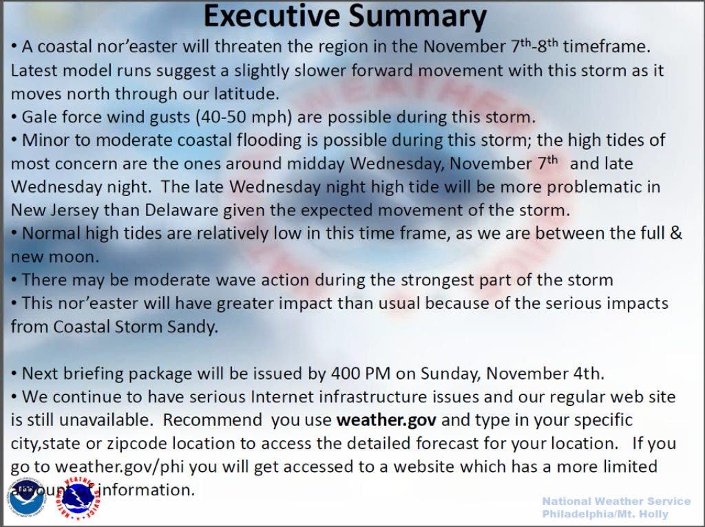
Nor’easter Threat
The upper air pattern over the US will continue with troughing over the eastern US and ridging over the west. A strong short wave will travel from the NW US into the base of the eastern US trough and help along the formation of surface low pressure over the SE US or along the SE US coast late this weekend/early next week. The upper level pattern is favorable for this trough to encourage the deepening of this surface low into a coastal storm as it passes very near the North Carolina coast and then moves NNE toward New England toward the middle of next week. The ECMWF and GFS models are in fairly decent agreement on the track of this system and impacts would be felt over the mid-Atlantic and NE US.
It is still several days away, and forecast models are not showing an overly strong storm system, but even a mild storm will only delay ongoing recovery operations. Current forecast suggest increasing winds and rains over the Sandy impact region by Tuesday with potential for winds of 30-50mph by Wednesday as the coastal storm moves across the nearshore coastal waters. Onshore winds will direct wave action back toward the coast and with dune protection completely destroyed, some coastal overwash will be possible. Structures heavily damaged or near the point of collapse may not survive addition wave action and beach erosion.
Much colder air will be in place with this storm and rain may transition to frozen precipitation over the higher terrain of the NE and mid-Atlantic states. Gusty winds will likely delay power restoration and may cause additional power outages due to the fragile conditions of the above ground lines and weakened vegetation in the region.
The threat and impacts will be fine tuned over the next few days.
NOAA Response Images: Mapping application of aircraft images for the entire New Jersey coast. Long Island is underway. These images will be used to determine before and after coastal change:
http://storms.ngs.noaa.gov/storms/sandy/
Please remember, whenever you need weather information, please visit us at the new and improved DaculaWeather.com. You can also get the latest weather information by following us on Twitter and Facebook