Health & Fitness
Sandy a 'Massive and Highly Destructive Storm'
How fitting to have evil Sandy for Halloween.

I wanted to pass this along, just got this a few minutes ago...
--------------------------------------------
E-mail from Jeff Lindner (Pro Met Harris County, TX Flood Control District):
Unprecedented cyclone impact to the NE US and mid Atlantic over the next 72 hours will require a significant and coordinated local, state and federal response.
Life threatening record breaking storm surge event likely for northern New Jersey and New York Harbor including Long Island Sound, the Hudson River, and Raritan Bay.
Preparations to protect life and property must be completed by dark today…failure to comply with mandatory evacuation orders will place lives in danger.
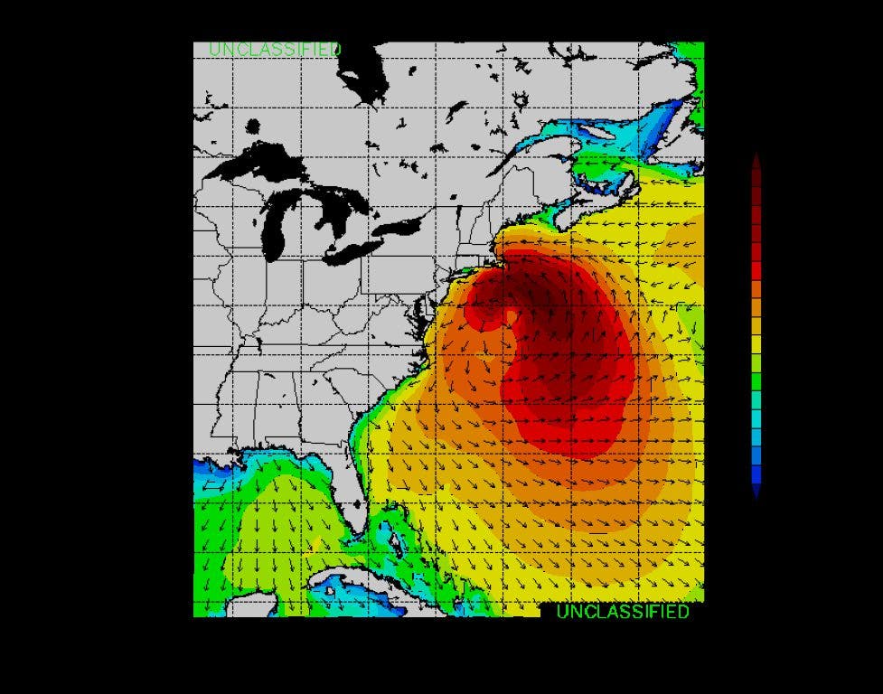
Hurricane Sandy becomes the second largest tropical cyclone ever in the Atlantic basin with tropical storm force winds extending outward 520 miles from the center and hurricane force winds 175 miles from the center.
Discussion:
Unfortunately, historic ingredients coming together exactly as forecasting models have predicted to bring a massive and highly destructive storm to the eastern 1/3rd of the United States.
Hurricane Sandy moving to the NE this morning well off the North Carolina coast however tropical storm force winds and high seas are battering the eastern part of North Carolina and spreading northward toward the lower DELMARVA area. Latest recon passes indicate a central pressure down to 951mb or nearly equal to Hurricane Ike….only much larger in size. The wind field continues to expand outward as Sandy is increasingly coming under more mid latitude influences however deep convection is being maintained near the center of the system and Sandy remains a tropical cyclone at this time.
There is little spread now in the forecast track of Sandy and its post tropical “mega” storm with nearly all available meteorological tools showing the center of the system crossing the central New Jersey coast Monday evening near the time of high tide! The GFS is forecasting an absolutely astounding 53mb pressure fall in 6 hrs along the New Jersey coast Monday evening as this storm moves ashore.
Forecasted central pressures for the system as it makes landfall look to break historical pressure records which range from the mid to low 960’s for nearly all the major eastern US cities. For comparison, the current central pressure of Sandy would break all pressure records in this part of the country by 10-15mb. The current 951mb pressure is already significantly lower than the 1991 Perfect Storm: 972mb and the superstorm of 1993: 960mb both of which crippled the eastern US.
Impacts:
Storm Surge
A “worst case” track for life threatening and devastating storm surge is likely for northern New Jersey and New York City including Long Island and Long Island Sound. It is likely that Sandy will be moving onshore Monday evening very near the lunar high tide peak only worsening the potential for record breaking storm surge. Extra-tropical storm surge modeling is producing record values for the northern New Jersey coast at Sandy Hook and at the NYC Battery. The previous Sandy Hook, NJ record is 10.1 ft in 1960, and the forecast for Monday evening is a peak surge of 11-12 feet. Surge values at the western end of Long Island Sound pushing toward eastern New York City are on the order of 11-13 feet and 10-11 feet at “The Battery” in NYC. For comparison, Hurricane Irene last year produced about a 6 foot storm surge into western Long Island Sound and NYC. This is a perfect setup for a large and destructive sea water inundation event over the north New Jersey and New York coast. Areas that have never flooded before will likely flood with sea water in this event and it is likely that sea water will enter and flood the New York City subway system.
Wave watch III models and local SWAN modeling shows massive offshore waves of 25-40 ft breaking at 15 feet on the beaches. Dune protection will be completely destroyed and as the storm surge and high tide peak Monday evening, large and destructive wave action will be aimed into coastal structures….many structures will be battered to the point of total collapse or washed into the ocean. Surge and wave action will likely overtop the Jersey boardwalk and seawall protection especially along the northern New Jersey coast.
On a scale of 0-6, this storm has a 5.2 storm surge damage rating!
Winds:
Strong winds will begin to arrive on the coast this evening and spread inland on Monday with the greatest winds expected Monday afternoon into Tuesday morning. Sustained winds of 35-50mph with frequent gust to 65-80mph will occur from the DELMARVA To southern New England and well inland over much of the NE US, eastern Canada, and portions of the OH valley. Winds will batter this area for 20-48 hours producing a long duration event. Trees and power lines will give way over time and suspect that this storm will produce one of the largest if not the largest power outages ever in the US. It is likely that over 10-20 million persons will be without power as this storm passes. Power restoration and debris clean up will take weeks!
Rainfall:
Rainfall totals of 4-8 inches will be common over a large area of the NE US and mid-Atlantic resulting in major inland flooding. Isolated totals of 12 inches will be possible over the DELMARVA. Historically flood prone areas will likely experience flooding with rivers and creeks possibly recording major flooding levels.
Snow:
Heavy wet snow will be possible on the backside of the system over portions of WV and eastern OH as the cold air sweeps into the backside of the system. Totals of 12-18 inches will be possible, but due to the wet nature of the event, trees will likely be brought down due to the weight of the snow.
Significant and potentially long term disruptions in travel are likely!