We had a close call last Friday with the system that brought ice to parts of north Georgia. But what's the saying, close is only good with horseshoes and hand grenades?
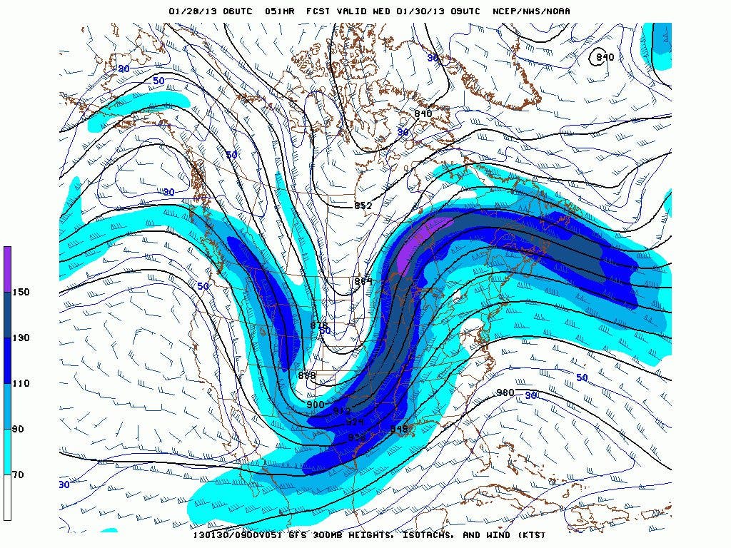
It looks like severe weather will be coming to our area on Wednesday. This is going to primarily be a wind and rain event, although a quick spin up tornado is not out of the question. An upper low that is currently over the southwest US is expected to advance east through the day on Tuesday. The upper level jet at both 200 mb and 300 mb are expected to line up (see the 200mb, 300mb, and 500mb maps above) and combine to bring a portion of those winds toward the surface, both in advance of the squall line and during it's passage. There will be quite a gradient as the system approaches, and winds in advance of the actual rain could be quite strong. Combine those winds with the still moist soil, and you have a recipe for considerable damage. Huntsville NWS had this to say about the winds:
THE OBVIOUS THREAT WITH THIS EVENT WILL BE WIDESPREAD DAMAGING WINDS
(WHICH MAY REACH/EXCEED 70MPH), WITH LOCALLY HEAVY RAINFALL A CLOSE
SECOND. PWATS OF 1.6" ARE BETWEEN THE 99TH PERCENTILE AND RECORD
VALUES FOR THIS TIME OF YEAR. THOUGH THE LINE WILL BE MOVING RAPIDLY
ACROSS THE AREA, IT WILL PRODUCE VERY HEAVY RAINFALL AMOUNTS IN A
SHORT PERIOD OF TIME (UPWARDS OF AN INCH IN 30 MINS OR LESS ARE
LIKELY), SO THIS MAY BRIEFLY LEAD TO PONDING OF WATER ON AREA
ROADWAYS. NO WIDESPREAD FLOODING ISSUES ARE EXPECTED, BUT THIS WILL
BE SOMETHING TO WATCH IF THE SYSTEM SLOWS DOWN.
The models have picked up the pace for this system and it now appears it will arrive here very late tonight or in the morning on Wednesday. There will be heavy rain accompanying this system with the HPC showing as much as two inches over portions of north Georgia. Once again like last Friday, we were stuck in the wedge and kept our temperatures in the 40s for most of the day on Monday. Today will be a different story with warm moist gulf air, from the surface to the mid levels of the atmosphere. Temperatures could hit 70 here depending on the sunshine or lack of.
Colder air returns after the frontal passage with highs on Thursday only in the 40s again. There is a chance that Thursday night/early Friday, parts of north Georgia could see a few flurries, as well as again Saturday night which might be a better chance. None of these are major events and may end up passing to our north again.
We're going to be in for a roller coaster ride for February with cold periods intermingled with warm-ups, and there are signs that March may end up as the coldest month of the winter. I'll have more on this in a new post.
Please remember, whenever you need weather information, please visit us at the new and improved DaculaWeather.com. You can also get the latest weather information by following us on Twitter and Facebook
DaculaWeather.com... Your Window to the Weather
TORNADO WARNING NATIONAL WEATHER SERVICE PEACHTREE CITY GA 1245 PM EST WED JAN 30 2013 THE NATIONAL WEATHER SERVICE IN PEACHTREE CITY HAS ISSUED A * TORNADO WARNING FOR... CHEROKEE COUNTY IN NORTH CENTRAL GEORGIA NORTHERN COBB COUNTY IN NORTH CENTRAL GEORGIA NORTH CENTRAL FULTON COUNTY IN NORTH CENTRAL GEORGIA SOUTHEASTERN BARTOW COUNTY IN NORTHWEST GEORGIA PAULDING COUNTY IN NORTHWEST GEORGIA
http://www.daculaweather.com/4_spc_storm_reports.php
BULLETIN - EAS ACTIVATION REQUESTED SEVERE THUNDERSTORM WARNING NATIONAL WEATHER SERVICE PEACHTREE CITY GA 131 PM EST WED JAN 30 2013 THE NATIONAL WEATHER SERVICE IN PEACHTREE CITY HAS ISSUED A * SEVERE THUNDERSTORM WARNING FOR... SOUTH CENTRAL CHEROKEE COUNTY IN NORTH CENTRAL GEORGIA COBB COUNTY IN NORTH CENTRAL GEORGIA NORTHWESTERN DEKALB COUNTY IN NORTH CENTRAL GEORGIA DOUGLAS COUNTY IN NORTH CENTRAL GEORGIA CENTRAL FULTON COUNTY IN NORTH CENTRAL GEORGIA WEST CENTRAL GWINNETT COUNTY IN NORTH CENTRAL GEORGIA EAST CENTRAL CARROLL COUNTY IN NORTHWEST GEORGIA SOUTHEASTERN PAULDING COUNTY IN NORTHWEST GEORGIA
http://www.daculaweather.com/national_alerts/4_severe_alert.php
THE NATIONAL WEATHER SERVICE IN PEACHTREE CITY HAS ISSUED A * SEVERE THUNDERSTORM WARNING FOR... SOUTHEASTERN CHEROKEE COUNTY IN NORTH CENTRAL GEORGIA EASTERN COBB COUNTY IN NORTH CENTRAL GEORGIA DEKALB COUNTY IN NORTH CENTRAL GEORGIA EASTERN DOUGLAS COUNTY IN NORTH CENTRAL GEORGIA SOUTHWESTERN FORSYTH COUNTY IN NORTH CENTRAL GEORGIA FULTON COUNTY IN NORTH CENTRAL GEORGIA GWINNETT COUNTY IN NORTH CENTRAL GEORGIA NORTH CENTRAL COWETA COUNTY IN WEST CENTRAL GEORGIA * UNTIL 300 PM EST * AT 210 PM EST...NATIONAL WEATHER SERVICE METEOROLOGISTS HAVE INDICATED A SEVERE THUNDERSTORM WITH A HISTORY OF PRODUCING QUARTER SIZED HAIL AND ALSO CAPABLE OF 60 MPH WINDS. THIS STORM WAS LOCATED 7 MILES SOUTH OF LITHIA SPRINGS...MOVING NORTHEAST AT 65 MPH. * OTHER LOCATIONS IN THE WARNING INCLUDE BUT ARE NOT LIMITED TO EAST POINT...HAPEVILLE...ATLANTA...GRANT PARK-ZOO ATLANTA...MIDTOWN... SMYRNA...BUCKHEAD...DRUID HILLS...DECATUR...AVONDALE ESTATES... CLARKSTON...SANDY SPRINGS...PINE LAKE...CHAMBLEE...STONE MOUNTAIN...DUNWOODY...DORAVILLE...TUCKER...ROSWELL...MOUNTAIN PARK...NORCROSS...LILBURN...BERKELEY LAKE...ALPHARETTA... SNELLVILLE...DULUTH...MILTON...JOHNS CREEK...GRAYSON... LAWRENCEVILLE...SUWANEE...DACULA...SUGAR HILL...CUMMING AND BUFORD.
NATIONAL WEATHER SERVICE PEACHTREE CITY GA 257 PM EST WED JAN 30 2013 GAZ001>009-011>016-019>022-030>033-041-310500- /O.CON.KFFC.FA.A.0002.000000T0000Z-130131T0500Z/ /00000.0.ER.000000T0000Z.000000T0000Z.000000T0000Z.OO/ DADE-WALKER-CATOOSA-WHITFIELD-MURRAY-FANNIN-GILMER-UNION-TOWNS- CHATTOOGA-GORDON-PICKENS-DAWSON-LUMPKIN-WHITE-FLOYD-BARTOW- CHEROKEE-FORSYTH-POLK-PAULDING-COBB-NORTH FULTON-HARALSON- INCLUDING THE CITIES OF...CALHOUN...DAHLONEGA...CLEVELAND... ROME...CARTERSVILLE...MARIETTA...ATLANTA 257 PM EST WED JAN 30 2013 ...FLOOD WATCH REMAINS IN EFFECT UNTIL MIDNIGHT EST TONIGHT... THE FLOOD WATCH CONTINUES FOR * MUCH OF NORTH GEORGIA...GENERALLY ALONG AND NORTH OF A LINE FROM BUCHANAN TO ATLANTA TO CLEVELAND. * UNTIL MIDNIGHT EST TONIGHT * A STRONG COLD FRONT HAS BROUGHT SHOWERS AND THUNDERSTORMS INTO NORTH GEORGIA. ONE TO THREE INCHES OF RAIN HAS ALREADY FALLEN IN AN AREAS FROM TRENTON TO HIAWASEE TO CARROLLTON. ANOTHER HALF INCH IS POSSIBLE IN THESE AREAS. EAST OF THIS AREA...AN ADDITIONAL ONE TO TWO INCHES IS POSSIBLE. * THESE RAINFALL AMOUNTS COULD COMBINE WITH THE SATURATED GROUND TO PRODUCE RAPID RISES ON SMALL CREEKS AND STREAMS...WITH FLOODING OF LOW LYING AND FLOOD PRONE AREAS POSSIBLE.
FLOOD WARNING NATIONAL WEATHER SERVICE PEACHTREE CITY GA 420 PM EST WED JAN 30 2013 ...THE NATIONAL WEATHER SERVICE IN PEACHTREE CITY HAS ISSUED A FLOOD WARNING FOR THE FOLLOWING CREEK IN GEORGIA... CROOKED CREEK NEAR NORCROSS AFFECTING FULTON AND GWINNETT COUNTIES .RECENT HEAVY RAINFALL HAS CAUSED SIGNIFICANT RUNOFF INTO STREAMS AND RIVERS WHICH WILL CAUSE FLOODING IN SOME AREAS. THE NATIONAL WEATHER SERVICE IN PEACHTREE CITY HAS ISSUED A * FLOOD WARNING FOR THE CROOKED CREEK NEAR NORCROSS. * FROM THIS AFTERNOON UNTIL FURTHER NOTICE. * AT 400 PM WEDNESDAY THE STAGE WAS 10 FEET...AND RISING. * MINOR FLOODING IS FORECAST. * FLOOD STAGE IS 11 FEET. * THIS CREEK SHOULD RISE TO NEAR 11.5 FEET BY THIS EVENING. IT WILL FALL BELOW FLOOD STAGE LATER TONIGHT. * AT 11 FEET...MINOR FLOODING OF THE NATURAL FLOOD PLAIN BEGINS MAINLY ON THE LEFT BANK UPSTREAM AND DOWNSTREAM FROM THE RIVER GAUGE AT SPALDING DRIVE.
http://www.daculaweather.com/4_video_wed.php
TOR SVR FFW SMW Yesterday: 75 263 27 27 Two days ago: 87 204 13 3 ================================ 162 467 40 30 TOR - Tornado Warnings SVR - Severe Thunderstorm FFW - Flash Flooding SMW - Marine warnings
http://www.srh.noaa.gov/ffc/?n=tornadoevent_013013
http://www.srh.noaa.gov/ffc/?n=tornadoevent_013013 Scroll toward the bottom