Everyone have fun with (no) snow?! I know, trust me, I'm leaning toward any forecast that includes the words snow/sleet/ice, and there was a shot the other day, it just didn't quite pan out.
The storm track was too far north and there was basically no cold air to work with. We were hoping for a more dynamic storm here but as it started to lift north it opened up and most of the energy was transferred away from our area. The mountains blocked any low level wrap around moisture so we were left high and dry. That was not the type of system we're looking for to get a good snowstorm here though. I'll do a little research and show you how some of the great Atlanta snowstorms have evolved and where they tracked.
I hear people getting antsy about no serious cold already. Tommy is already poo-pooing the idea that the strat warming occurred and it was all a government plot (sorry, just kidding Tommy! :-)) and Kristi wants 70+ degrees for the rest of the winter. But guys... it's coming, like it or not! :-)
Back on January 7th I said that our record warm temperatures would peak around the 13-15th and we actually peaked on the 12th at 71ºF went to 63 on the 16th and lower from there.
On the 11th I thought the cold air would be delayed until the 20-24th which would correspond with the cold shot we're getting Monday/Tuesday. This will be a transient shot and will quickly get pushed eastward by a Pacific low crashing through the western ridge.
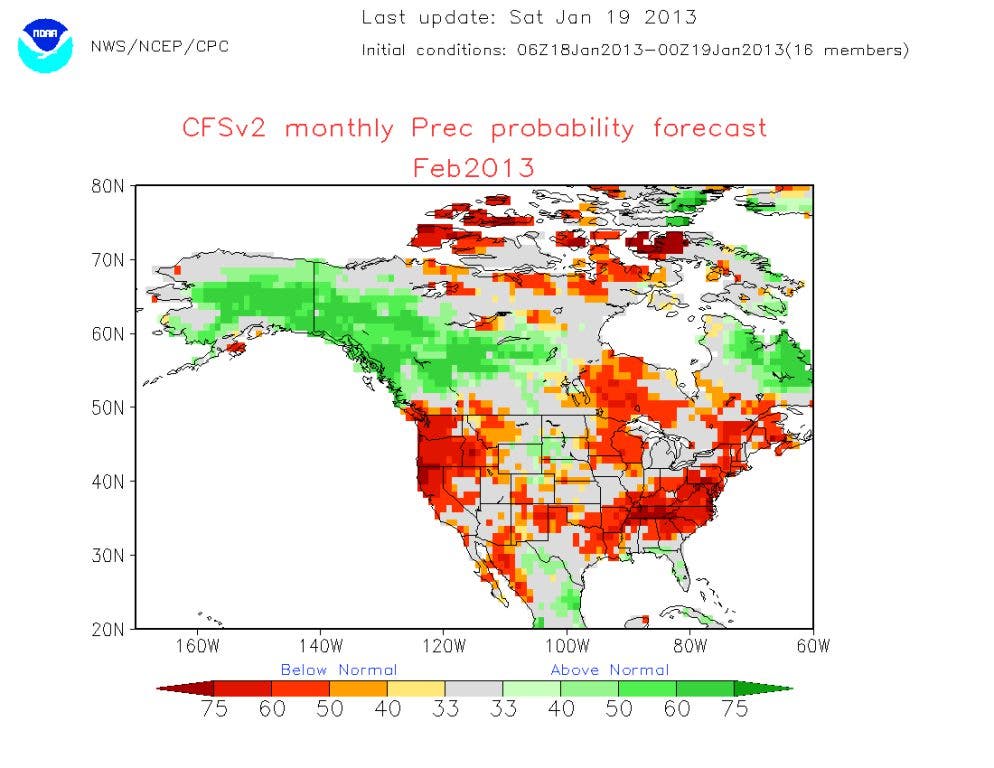
Don Sutherland, a name you'll you'll come to recognize if you follow my post, gave his thoughts last night about the upcoming pattern. "As we head toward February, one of the stronger analogs that has been coming up over the past week is 1967. Adding support for that emerging idea is the recent cooling ofENSO Region 3.4 and the latest CFSv2 monthly forecast (these images are above or click here for temp and precip). If this emerging idea is right, February could wind up the coldest month of the winter relative to normal across much of North America."
Another meteorologist with an intimate knowledge of the GWO or Global Wind Oscillation, had some follow up thoughts after Don. "Just a quick up date, got the revised GWO numbers in earlier today and as HM and I have been eluding to, there is lots of chaos in the atmosphere this week especially, but also the up coming week, so I'd take extra precaution with the GWO numbers. As talked about the other day, the xt RTW that was in the Pacific back on Wednesday appears it will still be coming over the ridge while breaking it down a bit, and still on schedule to arrive late 24th/early 25th east of the MS. Ushering cooler air for Jan 26-29 (matching Don's thoughts) and a reinforcement of colder air for Jan 31-Feb 2 (this one looks like a decent shot) and then a 5-10 degree warm up for Feb 2-4 with another S/W-shot of cold Feb 5-7 (decent shot of cold here to) and S/W cooler air Feb 7-11. There is a xt RW over India right now that I circled that times out to arriving Feb 4/5 which adds credence to the Feb. 5-7 time frame for a S/W moving through the East Coast."
So this is the way it's looking:
- Jan 24 - 25 - Stormy
- Jan 26 - 29 - Cold shot
- Jan 31 - 02 - Reinforcing good cold shot
- Feb 02 - 04 - Warm-up
- Feb 05 - 07 - Stormy/ good cold shot
- Feb 07 - 11 - Stormy/ cold shot
I am no expert on the GWO... so I have to trust the experts here. These two have pretty much nailed this winter so far, so I'm excited to see how their forecast turns out. Right now I see no reason to deviate from their thoughts or mine, either way, we can all track it together.
The more sustained cold will occur the last week of the month well into February. There will be multiple chances for winter precipitation during that period. Temperatures will be below normal to well below normal with occasional quick warm-ups in between. We haven't seen our last chance for snow by any stretch of the imagination, and February and March are some of the best months for snow in our area, a cold February will most certainly help those odds.
Please remember, whenever you need weather information, please visit us at the new and improved DaculaWeather.com. You can also get the latest weather information by following us on Twitter and Facebook
Pitiful isn't it... ;-)
http://www.daculaweather.com/4_forecast_gwinnett.php
I'm liking the sound of this more and more...a few excerpts: EXTENDED FORECAST DISCUSSION NWS HYDROMETEOROLOGICAL PREDICTION CENTER COLLEGE PARK MD 407 AM EST MON JAN 21 2013 VALID 12Z THU JAN 24 2013 - 12Z MON JAN 28 2013 GIVEN THE COLD ANTECEDENT CONDITIONS...THIS SYSTEM WILL LIKELY RESULT IN CONSIDERABLE ICE/SNOW AMOUNTS ALONG AND NEAR THE TRACK OF THE LOW. ...UPDATE... ALL PARAMETERS FOR DAYS 3 AND 4 WERE UPDATED TO REFLECT A 00Z UKMET/00Z GEFS MEAN COMPROMISE... WHICH IS MUCH SLOWER AND SOUTHWARD WITH THE LOW TRACK FROM THE SOUTHERN PLAINS TOWARD THE OHIO VALLEY.
What we'll get starting this afternoon will bring us back to slightly below normal for a day or two with a quick warm-up before the next system arrives toward the end of the week. This still falls in line with the timeline in my original post of stormy weather for the 24-25th (maybe 26th) with colder air behind that.
http://blog.timesunion.com/weather/the-tropics-affect-our-weather-madden-julian-oscillation/1257/ http://www.daculaweather.com/4_mjo_phase_forecast.php
http://www.daculaweather.com/4_nh_wv_loop.php
.LONG TERM /WEDNESDAY THROUGH MONDAY/... SOMEWHAT MORE ACTIVE LONG TERM PATTERN DEVELOPING. NW FLOW PATTERN WILL TRANSITION TO ZONAL FLOW BY THURS. SHORTWAVE PROGGED TO DROP SE INTO THE MIDWEST STATES FRI WITH FRONT TRAILING INTO MID MS VALLEY. THIS FRONT AND ANTECEDENT WARM/MOIST ADVECTION SHOULD BE SUFFICIENT FOR WIDESPREAD LIGHT-MDT RAIN EVENT. APPEARS INSTABILITY WILL NOT BE ENOUGH FOR EVEN ELEVATED CONVECTION SO HAVE KEPT TSRA OUT OF FCST. STRONG ARCTIC HIGH PUSHING IN BEHIND FRONT. ALTHOUGH CLIMATOLOGICALLY RARE TO SEE SNOW WITH NW FLOW ALOFT BEHIND FRONT...COULD SEE SOME FLURRIES OR LIGHT SNOW SHOWERS BEFORE PRECIP ENDS...ESP IF UPPER LOW COULD BECOME MORE CLOSED OFF THAN CURRENT MODEL RUNS SHOWING. AS IT STANDS NOW BASED ON 12Z GFS/12Z ECMWF...WILL PROBABLY NOT SEE ANY SNOW BUT HAVE ADDED SLT CHC OF RAIN OR SNOW SHOWERS TO FCST TO ACCOUNT FOR UNCERTAINTY IN POSSIBLE OCCLUSION OR MORE INTENSE ARCTIC AIR IN LATER MODEL RUNS. INTENSITY OF COLD AIR COULD BE QUITE STRONG. 12Z ECMWF HAS TAKEN A TURN FOR THE COLDER COMPARED WITH 00Z RUN AND 00Z ECMWF MOS WAS ALREADY QUITE A BIT COLDER THAN GFS MOS TEMPS. WILL CONTINUE TO MONITOR THIS BUT WOULDNT BE SURPRISED IF TEMPS TREND COOLER WITH SUBSEQUENT MODEL FCSTS.
THE MOST PUZZLING PART OF THIS FORECAST PACKAGE...AS IT HAS BEEN FOR THE LAST FEW DAYS...IS THE TEMPERATURE GUIDANCE OVER THE NEXT 5-7 DAYS. MODELS ARE STRUGGLING MIGHTILY WITH HOW COLD IT WILL BE AT NIGHT AND HOW WARM IT MAY GET EACH DAY. I DON'T THINK I'VE EVER SEEN A 6 STD IN THE ENSEMBLE GUIDANCE...AND COUPLE THAT WITH A 20 DEGREE RANGE IN THE GFS ENSEMBLES THURSDAY AND THURSDAY NIGHT...WE COULD GET THINGS HANDED TO US COME VERIFICATION TIME. WON'T MAKE ANY MAJOR CHANGES RIGHT NOW AND HOPE FOR SOME BETTER GUIDANCE WITH UPCOMING MODEL RUNS.
Jan 26 - 29 - Cold shot - Saturday 26th Jan 28 - 29 - Warm-up = Tommy tills his garden Jan 31 - 02 - Reinforcing good cold shot - Feb 02 - 04 - Warm-up = Tommy plants his garden Feb 05 - 07 - Stormy/ good cold shot Feb 07 - 11 - Stormy/ cold shot = Tommy's garden freezes twice :-) Could be a little warm up in between those two Jan cold shots but I highly doubt 70's then. We'l see who's correct! :-)
6z GFS has a nice light freezing rain/sleet event across much of north GA for at least the first half of Friday. The sounding for Dahlonega at 1pm Friday which shows temps in the 20's. Backing it up a bit to the 1am Friday sounding shows solid below freezing wetbulb column before the precip arrives. So IMHO that could equal a brief start as sleet/snow before the mid levels warm to change all precip to sleet/freezing rain. Something to watch for sure.
The southern extent of the ZR keeps getting further south in GA. The 18z 1/21 GFS had gotten down to Cumming/Gainseville. The 0z 1/22 GFS had reached all of the way down to Marietta with a tiny amount (~.01") The 1/22 6z GFS is all of the way down to the southside of Atlanta at the airport with a tiny amount while it gives Marietta nearly .10". It is mainly about the colder trends right now as the models play catch-up with the intensity of the cold, dry air that will be in place initially. All of this is being shown without the aid of cold easterly winds. The modeled winds are still SE and, yet, there is some ZR that is trending further south. Imagine how much more significant this could get if the runs start showing ZR locking east winds as well as heavier precip. With the potential event still 78 hours out, there's still plenty of time for this to evolve. Analogs and climo are keeping me on my toes with this threat.
PLEASE don't let them mess with it! :-)
PROGNOSTIC DISCUSSION FOR 8 TO 14 DAY OUTLOOK NWS CLIMATE PREDICTION CENTER COLLEGE PARK, MD 300 PM EST TUE JANUARY 22 2013 THE ENSEMBLE MEANS AND DETERMINISTIC RUNS FOR WEEK 2 HAVE COME INTO BETTER AGREEMENT OVER THE PACIFIC-NORTH AMERICA DOMAIN, ESPECIALLY IN THE VICINITY OF ALASKA. THE GFS, EUROPEAN AND CANADIAN-BASED MODELS ALL AGREE THAT THE EASTERN PACIFIC RIDGE WILL REACH THE WEST COAST, BUT MORE IMPORTANTLY AMPLIFY ACROSS ALASKA AND MUCH OF THE ARCTIC OCEAN. HAVING TWO DISTINCT POLAR VORTICES PREDICTED IN THE 500-HPA GEOPOTENTIAL HEIGHT FIELD (ONE CENTERED OVER HUDSON BAY, AND THE OTHER CENTERED ALONG THE NORTHERN COAST OF RUSSIA), WOULD ENABLE DELIVERY OF BITTERLY COLD ARCTIC AIR FROM NEAR THE NORTH POLE SOUTHWARD ACROSS CENTRAL CANADA AND INTO THE CENTRAL AND EAST-CENTRAL CONUS. ODDS FOR ABOVE-NORMAL TEMPERATURES ARE STILL ENHANCED ACROSS PARTS OF THE SOUTHEAST EARLY IN THIS PERIOD, IN ADVANCE OF THE ANTICIPATED ARCTIC AIR OUTBREAK. IT IS IMPORTANT TO EMPHASIZE THAT THE EXPECTED SPATIAL EXTENT OF THIS VERY COLD AIR HAS BEEN TEMPERED SOMEWHAT DUE TO DIFFERENCES BETWEEN THE VARIOUS SURFACE TEMPERATURE TOOLS, AND MAY BE FARTHER SOUTH AND EAST THAN WHAT IS CURRENTLY INDICATED.
Really interesting VERY heavy snow with lighting
"My point is that if there were to be ~0.25" of freezing rain on Friday in much of N GA, it shouldn't be trivialized by any means. That would be a pretty sig. winter storm in its own right and wouldn't have been exceeded in over 7 years in terms of ZR amounts in Atlanta at least."
MODEL CONSENSUS SHOWING GREATER THAN 80 PCT PROB OF 0.01 INCH OF FREEZING RAIN...WITH THE DETERMINISTIC FORECAST SHOWING A SWATH OF 0.10 TO 0.25 INCHES FROM NORTHWEST GA...SOUTH THROUGH THE ATLANTA METRO EASTWARD ALONG I20 INTO SC. WILL LET LATER SHIFTS HONE IN ON BOTH AMOUNTS AND TIMING AS THE EVENT UNFOLDS.
...POTENTIAL FREEZING RAIN EVENT ON FRIDAY... .A COLD FRONT WILL MOVE THROUGH THE SOUTHEAST ON FRIDAY BRINGING PRECIPITATION TO THE AREA. COLD AIR AT THE SURFACE...ESPECIALLY WEDGED ALONG THE NORTH GEORGIA MOUNTAINS...WILL RESULT IN PRECIPITATION FALLING AS FREEZING RAIN AND SLEET. ...FREEZING RAIN ADVISORY IN EFFECT FROM 6 AM TO 1 PM EST FRIDAY... THE NATIONAL WEATHER SERVICE IN PEACHTREE CITY HAS ISSUED A FREEZING RAIN ADVISORY...WHICH IS IN EFFECT FROM 6 AM TO 1 PM EST FRIDAY. * LOCATIONS...PORTIONS OF NORTH GEORGIA...GENERALLY WEST AND SOUTH OF A LINE ELLIJAY TO CUMMING TO GAINESVILLE. PORTIONS OF CENTRAL GEORGIA...NORTH OF LINE FROM FRANKLIN TO GRIFFIN TO EATONTON TO CRAWFORDVILLE. * HAZARD TYPES...FREEZING RAIN. * ACCUMULATIONS....LESS THAN A TENTH OF AN INCH OF ICE...BEFORE THE FREEZING RAIN TURNS TO ALL RAIN AND MELTS. * TIMING...6 AM TO 1PM EST FRIDAY. * IMPACTS...ICE WILL CAUSE ROADWAYS AND SIDEWALKS TO BECOME SLIPPERY...MAKING TRAVEL DANGEROUS ESPECIALLY ON BRIDGES AND OVERPASSES. * WINDS...EAST 5 TO 10 MPH WITH GUSTS UP TO 20 MPH. * TEMPERATURES...AROUND 30 IN THE MORNING WARMING TO AROUND 40 BY AFTERNOON. Instructions: A FREEZING RAIN ADVISORY MEANS THAT PERIODS OF FREEZING RAIN OR FREEZING DRIZZLE WILL CAUSE TRAVEL DIFFICULTIES. BE PREPARED FOR SLIPPERY ROADS. SLOW DOWN AND USE CAUTION WHILE DRIVING.