I hope everyone had a very Merry Christmas!
Now that we've made it through the Christmas holiday, it's time to look ahead at the weather for New Year's eve and beyond.
Today will start off with temperatures below freezing, here at DaculaWeather.com we managed to hit 27.9º at 7:32 am this morning. Temperatures will rebound a little bit today under sunny skies, but there is still pretty good cold air advection (CAA) so it won't get too warm today. Clouds and moisture begin to return on New Year's eve but the day will remain dry. The rain reappears in the early hours of New Year's day and will remain with us off and on through at least Thursday.
The north Georgia mountains may see a little snow on Tuesday morning and again later in the week when another colder shot of air returns. There is a pretty good snow cover over the northern part of the country now, and each new shot of cold air brings the colder air further south since the snow cover helps prevent the air from warming as much as it would without it.
Find out what's happening in Daculawith free, real-time updates from Patch.
The models are still waffling on exactly what is going to happen for the system at the end of next week, so until things come into better focus, I won't speculate on the type of weather we may see, but we're entering the time of the year when the precipitation type becomes a challenge to predict. We will most likely have rain though. :-(
Here's a potential forecast for the month of January from several of the meteorologists I follow (WARNING, weather geek speak follows!):
Find out what's happening in Daculawith free, real-time updates from Patch.
-------
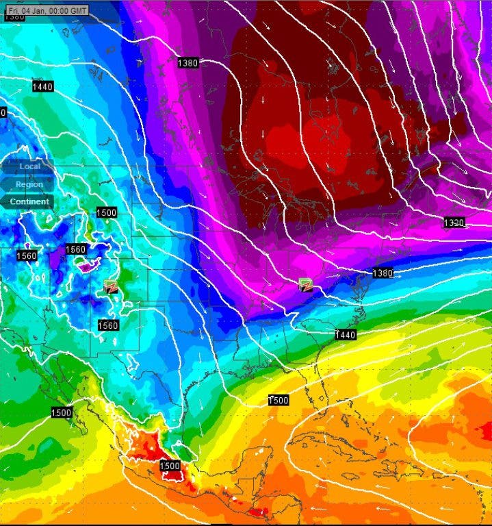
First Dec. 27-30 window as mentioned back on Dec. 13...we have the Euro 39h 850's for Dec. 30 with the cold pool of -10 to -12C air covering most of the MW/NE.
After a brief stint of southerly flow on the back side of a high pressure over Florida 850's warm to 0 to -2C over IN, OH and parts of MI for Dec. 31
Second window Dec. 30-Jan 3 as mentioned back on Dec. 13... signs still pointing to much colder air arriving over the Eastern US...the Euro at 156 hours 850's for Jan 4 0z---Jan 3 7pm EST with -20 to -22C over WI and N. MI which migrates eastward in the following days.
It appears the Jan 20-24 cold shot should be comparable in magnitude of the upcoming Jan 2-3 airmass. Also latest GWO numbers are currently trending towards an agreement of the Jan 20-24 date. I will have concrete confirmation or rejection of that assumption by Tues.
Extending the outlook Jan 24-26 show up as next pocket of cooler air...although I will say signals are mixed on this window date so I'm not too confident on this time frame producing a cooler airmass for the MW/NE.
(This next paragrpah has to do with stratospheric warming over the north pole area. Normally when that area of the stratosphere warms, it displaces the polar vortex southward. In this case, the models are showing a split as well as displacement.)
Although Jan 26-30 looks very impressive and should out do the Jan 2-3 850mb cold air wrt temps. The newest ECMWF strat. temp forecast shows a ~+48C warming at 10mb from Dec. 29 through Jan. 2 and a ~+42C warming from Jan1 to Jan 2. There is also a wind reversal forecasted to take place Jan 2 at 1mb and 10mb at 60N. This should qualify as a MAJOR SSW since only a +25C temp change is required over a week period for a minor SSW and I believe the wind reversal is extensive enough to qualify also. If not it is still a minor SSW. The EP vector is also forecasted poleward at least at 90N which is a good signal that the SSW will in fact allow arctic air to spill southward. This event should produce the Jan 26-30 window cold pocket...Although I don't have much experiencing timing out SSW events so this may not be the exact window, it may have to be adjusted forward or backwards by a few days.
I will also say that it appears a lot of these dates are back to back and should mention that these forecasted chunks of cooler/colder air are cooler/colder relative to the air in place that they displace. So I don't claim to know the temperature range of the 850mb temps arriving...The concept can only forecast that it will be "colder" than the one that will be in place at the time of it's arrival and are associated with shortwaves so there will be brief time frames of southerly winds ahead of the short waves that will produce WAA ahead of waves and as a result might produce brief minor spikes in 850 temps and sfc temps in transition from time frame to time frame. So for example over a period of days (windows) it could just go from -2C...cool to -5C (window/event 1) then warm to 0C and cool to -4 (window/event 2) where event 2 ends up "cooling" but ends up actually with warmer temps than just a few days prior but cooler compared to just 1 or 2 days prior. This also doesn't elude to AA temps or BA temps just "relative" so even with all the time frames for shortwaves thus...colder airmasses; it doesn't rule out that the resulting cooler temps still produce above average temperatures for daytime highs. When the signals are stronger an estimation of the temp of the air is possible such as the Jan. 2-3 and Jan 20-24 and Jan 26-30 episode. The other time frames are just hiccups in the stat. signal and coincide to minor dips in sfc temperatures relative to previous days' highs but I figure they are worth mentioning.
------------
And Mr. Sutherland had this to say:
------------
Near Year-End Wrapup...
A brutally warm year for North America is coming to a close. December has already produced some winter highlights in the Plains States, Midwest, and portions of Quebec. Madison and Montreal were among the cities receiving substantial snowfalls. A storm is currently poised to bring a moderate to locally significant snowfall to portions of New England.
Looking ahead, the PNA is continuing to rise. The long anticipated Arctic outbreak appears likely to occur during the first week in January. Ahead of the Arctic outbreak, some snow flurries and snow showers might occur, but a big storm probably won't.
Portions of southern Canada and the eastern half of the U.S. will likely see their coldest readings of the winter so far. Some areas, perhaps including New York City, Albany, and Ottawa could see their coldest temperatures since Winter 2010-11. A subzero low in Albany and single-digit low in New York City (even with little or no snow cover) remain on the table.
However, after the Arctic outbreak, with the Arctic Oscillation likely to go positive and the EPO also likely to become positive, a period of moderation is likely to unfold, beginning in the Plains States and than spreading eastward. Unlike last winter, it does not appear that a bout of exceptional warmth is underway. More importantly, it is likely that this will be the kind of moderation that lasts about two weeks. Hence, winter will not come to an end. Moreover, January is likely to have cold monthly anomalies for perhaps the eastern two thirds of the U.S., as well as southern Ontario and southern Quebec.
Finally, the upcoming storm should not be viewed as a missed opportunity for snowfall from which lightly or non-impacted regions cannot recover. It is not a final verdict that Winter 2012-13 will continue the misery of a general absence of snowfall in those regions e.g., the Mid-Atlantic where the last snowy winter was 2009-10. There will be more opportunities for snowfall and analog cases continue to suggest that a KU-type snowstorm is not out of the question before the winter is completed.
--------------
Please remember, whenever you need weather information, please visit us at the new and improved DaculaWeather.com. You can also get the latest weather information by following us on Twitter and Facebook DaculaWeather.com... Your Window to the Weather