


It's looking more and more like March will come roaring in like a lion next week. I've been talking about the possibilities of cold weather returning, and it appears to be on track as we thought.
As I've talked about before, the models just didn't get this winter right, the cold was always two weeks away, the rain was always in between the cold. They just could never quite get their act together to make a meaningful winter weather event. But it's looking like all of that is about to change toward the middle to the end of next week as we enter an active transitional period. A large cold trough will settle across the eastern US toward next weekend, bringing us some of the coldest temperatures of the winter season. The models have been hinting at the cold returning and now they are all converging on that same solution. The HPC had this to say this morning:
"ANOTHER TROUGH IN THIS SERIES IS ON ITS HEALS BACK ACROSS THE WEST MIDWEEK...BUT EXPECTED RAPID UPSTREAM FLOW AMPLIFICATION OUT FROM THE ERN PACIFIC HAS GOOD GUIDANCE SUPPORT TO LEAD TO DEVELOPMENT OF AN AMPLIFIED WRN US MID-UPPER LEVEL RIDGE BY LATE NEXT WEEK. THIS MAY FORCE THE LEAD IMPULSE TO AMPLIFY WITH NRN STREAM ENERGY INTO QUITE AN AMPLIFIED AND COLD E-CENTRAL US MID-UPPER LEVEL TROUGH IN A POSITIVE PNA PATTERN. DOWNSTREAM...TRENDS CONTINUED TOWARD AN INCREASINGLY BLOCKY (NEGATIVE) NAO PATTERN EMERGING IN THE NRN ATLANTIC HEADING INTO NEXT WEEKEND WITH HIGH LATITUDE HEIGHT RISES FEEDING WWD ACROSS SRN GREENLAND TOWARD ERN CANADA."
Find out what's happening in Daculawith free, real-time updates from Patch.
All winter when it appeared we would get cold, the blocking never materialized and the cold would never make it this far south, and instead would get pushed east. Not this time. And according to a comment I made in my previous post, Mr Sutherland seems to think that it's also possible to get some cross-flow polar air headed our way:
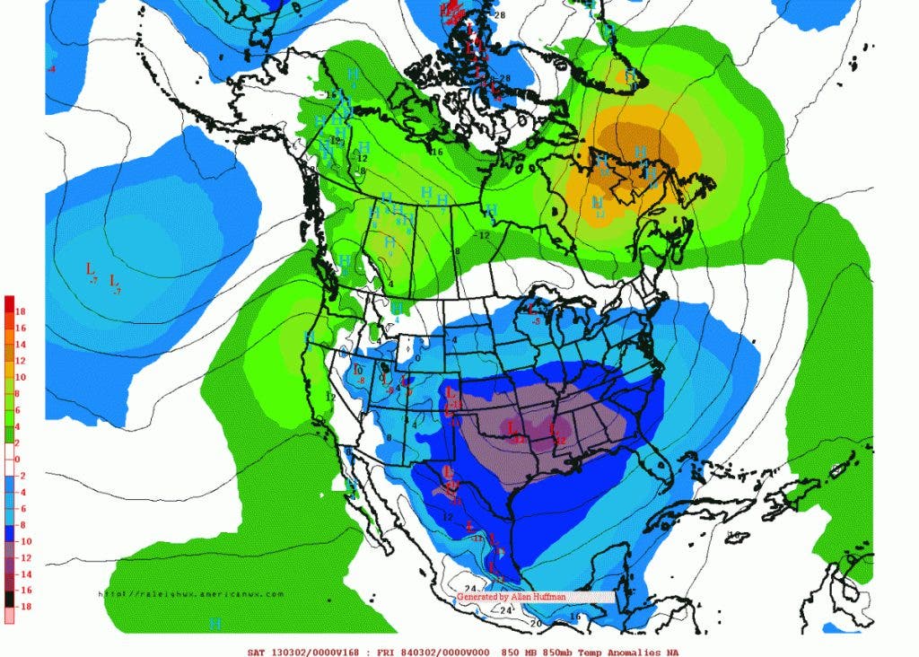
"Perhaps lending support to the idea, some of the ensemble guidance is now suggesting that the EPO could go negative during the first week in March. If that happens, prospects of at least a period of cross-polar flow could increase. That would tap into the cold in Russia and bring some this way. We'll just have to see how this evolves."
Find out what's happening in Daculawith free, real-time updates from Patch.
That's cold we don't want, but it's also not something we'll really have to worry about here. Seven of the coldest places in the northern hemisphere are in Russia this morning with low temperatures ranging from -57ºF to -67º F. What would happen to us if this pattern were to flip and that cold came over here? And seriously, it's not out of the question at some point in the future (not this year!).
Keep in mind, some of Atlanta's largest snow storms occurred in March. Because March is a transitional month, you get very dynamic systems that can create a large snowstorm over a large area. With the cold in place as the models are depicting, it forces upper waves and disturbances to ride around the base of the trough. Once they rotate toward the Gulf, it can cause a low pressure to form what is known as a "Miller A" type storm. These tend to become "Nor'Easters" as they pass up the eastern seaboard. The 1993 "Storm of the Century" was one of those.
Based on the most recent model trends, the first week of March will turn colder. So once again, my buddy Larry from Savannah, the master of Georgia weather statistics, had this to share about the expected temperatures for the first week of March for Atlanta:
"Per the 18Z Goofy (GFS) per MeteoStar, the average temp for KATL for March 1-5 will be 36 F. Now, I fully realize that the GFS has a cold bias, however in (KATL is Hartsfield airport) this case, the blocking is so impressive and the models have been so consistent that I can believe this 36º as a legit possibility. A 36º F would be a whopping 6º F colder than mid January! It is 15º F below normal. Also, KATL's coldest day to this point was 2/17's 36º F! Even if this run were 4º F too cold, it would still be a cold 40º F, which is 2º F colder than mid Jan.'s norm.
How cold would an average temperature of 36º F for March 1-5 be in relation to history at KATL?
- Since 1930, only one 3/1-5 was colder: the 28º F of 1960. 1960's March 1-5 had a major ZR (freezing rain) as well as 0.8" of snow.
- Tied for 2nd were four cases of 37's: 1943, 1975, 1978, and 1980. An impressive two of those 3/1-5's produced measurable snows: 1943 (0.4") and 1980 (2.7"). 1978 produced a T. 1975 had no snow.
- Tied for 6th at 38º were 1947 and 2002. 1947 had two days with traces. 2002 had none.
- Tied for 8th at 39º -were 1942 and 1962. 1942 had a major (3.7") whereas 1962 had two traces.
- Tied for 10th at 40º were 1930 (none), 1954 (none), and 2009 (major of 4.2").
So, to summarize, the coldest eleven March 1-5's since 1930 at KATL, whose values ranged from 29 to 40 F, had multi-inch snow 3 out of the 11, had measurable snow 5 of the 11, at least a trace of snow 7 of the 11, and a major freezing rain once. So, 4 of the 11 had either a major freezing rain or a multi-inch snow. Those are pretty respectable odds for just a five day period."
Then today, Larry added a few more stats for us to ponder:
"How cold could March 1-5 be relative to history in the southeast? I have the KATL stats. Keeping in mind the GFS cold bias, the 6Z GFS per MeteoStar has KATL at 31º F, which would be a whopping 20 below normal!!
Here are the coldest March 1-5's 1930-2012:
- -28 1960 major ZR and 0.8" S/IP
- -37 1943 0.4" S/IP
- -37 1975
- -37 1978 T of S/IP
- -37 1980 2.7" of S/IP
- -38 1947 2 T's of S/IP
- -38 2002
- -39 1942 3.7" S/IP
- -39 1962 2 T's of S/IP
- -40 1930
- -40 1954
- -40 2009 4.2" S/IP
Even if the 6Z GFS is off by 5º F, it would still be 36º F, the 2nd coldest since 1930!"
And finally... this from Steven Nelson, the Science and Operations Officer at the Atlanta NWS office:
"AS SHORT WAVE LIFTS INTO NEW ENGLAND...ANOTHER WAVE WITH COLD
ARCTIC AIR BEHIND IT DIVES INTO PLAINS AND CARVES OUT BROAD LONG
WAVE TROUGH OVER THE ERN 2/3RDS OF THE CONUS. THIS WILL MARK THE
BEGINNING OF A COLD PATTERN FOR LATE THIS WEEK AND INTO THE
WEEKEND. 00Z GFS/ECMWF IN GOOD AGREEMENT ON THIS PATTERN. AS FOR
PRECIP...ONLY LIGHT AMOUNTS POSSIBLE ON WED/THUR OVER NORTH GA.
CANT RULE OUT -SHRA/SHSN MIX OR EVEN ALL -SHSN AT ELEVATIONS
ABOVE 1500FT THURS/FRI. 850MB GFS/EC TEMPS PROGGED TO DROP TO -5C
WED NIGHT AND TO -10 TO -13C BY FRI/SAT. MAY BE HARD TO GET OUT OF
THE 30S ON SAT IF MODELS ARE TO BE BELIEVED."
Time is getting close, the models are very consistent now. This should be a fun next several weeks to watch. Stay tuned!
Please remember, whenever you need weather information, please visit us at the new and improved DaculaWeather.com. You can also get the latest weather information by following us on Twitter and Facebook DaculaWeather.com... Your Window to the Weather