A very active weather pattern, with just about any kind of weather you can imagine, from possible tornados and thunderstorms, to bitter cold with ice and snow, all separated by less than a couple hundred miles.
I was reading the Little Rock AFD this morning (Saturday) and I'm still amazed at the temperature difference across that state, with mid-teens in the NW corner while the SE corner was sitting at mid-30's. They are looking a temperatures tonight of zero, and maybe a little less than that the next night. We're talking COLD.
RECORDS
Just a few examples of records set these last few days:
------
Huntsville said this in their AFD on Friday morning:
AREA FORECAST DISCUSSION
NATIONAL WEATHER SERVICE HUNTSVILLE AL
225 AM CST FRI DEC 6 2013
.DISCUSSION...
AT 1 AM, A 31 DEGREE TEMPERATURE RANGE WAS FOUND ACROSS OUR FORECAST AREA (39 AT THA TO 70 AT 4A9).
-------------
From Montana:
"This morning's low (12/7) temperature at Havre, MT has so far been -39°. That reading is its third consecutive daily record low temperature and its coldest reading during the 2000-present period.
Its readings for the past two days have been:
Find out what's happening in Daculawith free, real-time updates from Patch.
12/5 High: -14° (broke daily record of -12°, 1880); Low: -28° (broke daily record of -27°, 1956)
12/6 High: -13°; Low: -38° (broke daily record of -31°, 1972
Find out what's happening in Daculawith free, real-time updates from Patch.
The 12/5 high was also the lowest high temperature during the 2000-present period"
-------------------------
From Georgia:
12/06/13 - Savannah, GA, tied its all-time December record with 83F. Records go back to 1874!
-------------------------
From Texas:
Temperature departures across much of Texas are running anywhere from -30 to -40 degrees below normal.
-------------------------
And Montana again:
"At Jordan, MT, the temperature fell to at least -42° this morning. That shattered the daily record of -37°, which was set in 1927. Today's frigid temperature was that city's first -40° temperature since January 12, 1998 when the temperature also fell to -40°. It was also that city's first December temperature of -40° or below since December 31, 1992 when the temperature reached -40°. It was the coldest reading since December 22, 1989 when the thermometer fell to -45°. Finally, it was the earliest -40° temperature on record beating the previous early date of December 21, 1989."
----------------------------
(Note: some of this was written on Saturday... )From this map here, you can see that temperatures in the western 2/3's of the country are well below normal, with some areas 40 degrees below normal, and this map shows the 24 hour temperature change. We haven't seen cold like this in the US in quite a while, and some places are breaking records that go back more than a hundred years.
For us... the stubborn SE ridge has reared it's ugly head and is bringing a very warm moist flow of air northward. If you like winter weather, the SE ridge is your arch enemy. It likes to sit out over the ocean, and block all the cold air from moving southward, and it's doing a fabulous job of it right now.
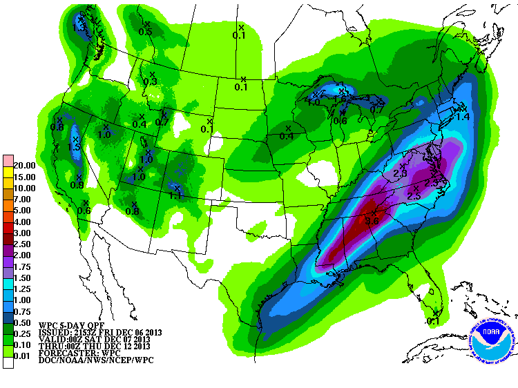
More rain will be on the way later today and on through the middle of next week. FFC had this to say in their Sunday morning discussion:
"AS WEDGE CONTINUES TO BUILD IN TODAY... SOUTH AND SOUTHWEST FLOW WILL INCREASE JUST OFF THE SURFACE AND THROUGH 10K FEET ALLOWING FOR A FAVORABLE ISENTROPIC UPGLIDE PROFILE BY LATE MORNING. RESULT WILL BE AN INCREASE IN BOTH PRECIPITATION COVERAGE AND INTENSITY WITH NORTH CENTRAL GEORGIA TARGETED INITIALLY BUT QUICKLY TRANSITIONING TO JUST NORTH GEORGIA THIS AFTERNOON AND EVENING. DIFFICULT TO TELL HOW MUCH WILL BE MODERATE RAIN... LIGHT RAIN... OR JUST DRIZZLE BUT COULD BE A BIT OF ALL THREE. DUE TO THE UNCERTAINTY WITH INTENSITY... STUCK CLOSE TO HPC QPF PROJECTIONS FOR THIS CYCLE. TEMPERATURES WILL BE VERY CHALLENGING TODAY AS LOCATIONS WITHIN THE WEDGE SHOULD SEE TEMPS ACTUALLY GO DOWN TODAY WHILE OTHER AREAS WILL SEE A MODEST INCREASE... ESPECIALLY ALONG THE EXTREME SOUTH."
This is an excerpt fro the Hydrologic Statement issued from the Atlanta NWS office, the full statement can be viewed here:
...PERIODS OF LIGHT RAIN POSSIBLE TODAY WITH HEAVIER RAIN AGAIN TONIGHT AND MONDAY OVER NORTH GEORGIA...
...FLOODING POSSIBLE TONIGHT INTO TUESDAY...
...RAINFALL EXPECTED... STORM TOTAL RAINFALL AMOUNTS OF 1.5 TO OVER 2.5 INCHES ARE FORECAST OVER NORTH GEORGIA THROUGH TUESDAY
...ISOLATED HIGHER AMOUNTS WILL BE POSSIBLE. THIS IS IN ADDITION THE 1 TO 2 INCHES THAT HAS FALLEN ACROSS PORTIONS OF NORTH GEORGIA OVER THE PAST COUPLE OF DAYS.
-----------------------------
Like what you read here and want to be notified of new posts and updates? You can subscribe to this weather blog by clicking here and then clicking on "Get email updates"
Please remember, whenever you need weather information, please visit us at DaculaWeather.com. You can also get the latest weather information by following us on
DaculaWeather.com... Your Window to the WeatDaculaWeather.com... Your Window to the Weat