
UPDATE - Sunday, 11:00am
I wanted to post this since it pertains to what I wrote a little futher down the page here. This is from a gentleman named Donald Sutherland (no... not the same )
------
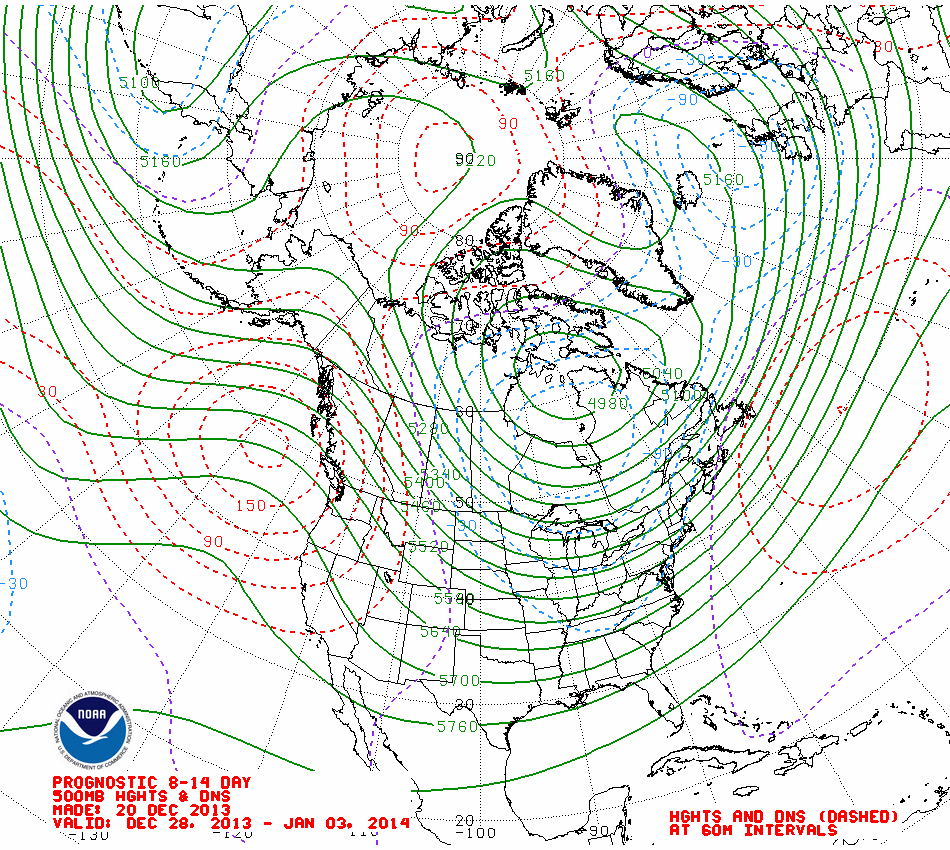
January 1-7, 2014 Thoughts:
Already, this morning record high temperatures had fallen in many cities in the eastern U.S. Cities included Atlanta, Baltimore, New York, Newark, and Philadelphia. Temperatures in that part of North America were running in the 60s and even 70s. However, if one looks ahead to the first week of January, a return of more winter like conditions appears increasingly likely.
The ensemble guidance have been suggesting a change in both the AO and PNA heading into the first week in January. Today's run shows the most decided signal yet for an AO- and PNA+ pattern. The EPO is forecast to remain predominantly negative. Nevertheless, given the PDO- and persistent AO+, some consideration has to be given to a more modest change in the indices.
The outcomes based on the forecast teleconnections and those shown on the GFS ensembles for 1/5/2014 0z are quite similar. As a result, my guess is that much of Canada, except for the extreme north and western portions will likely wind up colder than normal. A cold January looks increasingly likely across much of Canada, as well. Much of the CONUS will also wind up colder than normal with perhaps the coldest anomalies located somewhere near the Great Lakes region. Exceptions will be the western quarter of the U.S., particularly the Southwest and Pacific Northwest where warmer conditions appear likely. The Southeast and Gulf Coast may wind up close to normal with some warmer than normal anomalies, particularly across Florida where winter has been largely absent so far.
As an added bonus, the ensembles have consistently signaled the possibility of a storm that could develop somewhere in the Gulf region and then move off the coast of the Southeastern U.S./lower Mid-Atlantic. Storm tracks are low skill at this time, but the important point is that the cold might coincide with some storminess in parts of the eastern CONUS."
---------------------------------------
Our solar Winter will officially begin Saturday at 12:12pm, and will be greeted by spring like temperatures, very breezy winds, and rainy skies.
Obviously from my post on the 14th... the models were incorrect about the cold arriving here on the 22nd. The timing was there, just not the cold! What happened you ask? No blocking. Without some type of blocking regime, there is nothing to bring the cold air this far south. With a strongly positive AO and NAO, the cold air just passes to our north.
One thing we will see for the start of winter, is the possibility of severe weather. We have a rather deep upper level low sitting over the Baja of Mexico that will begin to make it's way east and then northeast as the weekend progresses. Fortunately, most of the energy moves to our north before the front gets here or it could be much worse. Here are some thoughts about the weekend weather from this evenings AFD from the Atlanta NWS office:
MAIN CONCERN STILL LATER SATURDAY NIGHT AND SUNDAY WITH POTENTIAL FOR ISOLATED SEVERE STORMS AND HEAVY RAIN. BEST CHANCE FOR SEVERE STORMS STILL LOOKS TO BE ALONG AND NORTH OF INTERSTATE 85.
MAX TEMPERATURES MAY REACH RECORD LEVELS SATURDAY AND SUNDAY IN PARTS OF THE CWA.
HYDROLOGY... LARGE AREA OF 2 TO 2.5 INCHES OF RAIN FORECAST ACROSS THE AREA THROUGH MONDAY WHICH COULD LEAD TO MINOR RIVER FLOODING. A FLOOD WATCH COULD BE ISSUED SATURDAY IF ANY GREATER AMOUNTS ARE FORECAST.
The Storm Prediction Center had this to say about severe weather in the 3 Day Outlook:
...ERN GULF COAST NEWD TO THE CAROLINAS/MID-ATLANTIC...
A CONVECTIVE LINE WILL LIKELY BE ONGOING AT THE START OF THE PERIOD ACROSS TN/AL SWD TO THE GULF COAST... ALONG OR AHEAD OF AN EWD MOVING COLD FRONT. WIND PROFILES ASSOCIATED WITH THE SRN FRINGE OF A LLJ WILL BE SUPPORTIVE FOR A FEW STRONG WIND GUSTS AND PERHAPS A TORNADO SUN MORNING WITHIN AND/OR AHEAD OF THE CONVECTIVE LINE. LOW-LEVEL FLOW AND FORCING FOR ASCENT SHOULD WEAKEN BY LATE MORNING/AFTERNOON ACROSS AL/GA AS THE PRIMARY SHORTWAVE TROUGH PULLS INTO CANADA. THE LINE SHOULD DECELERATE IN CONJUNCTION WITH THE COLD FRONT DURING THE DAY ACROSS AL/GA AND BECOME PRIMARILY A HEAVY RAIN THREAT... ALTHOUGH STRONG WIND GUST POTENTIAL WILL REMAIN NON-ZERO. A SLIGHT RISK UPGRADE COULD BE CONSIDERED IN SUBSEQUENT OUTLOOKS... ESPECIALLY FOR THE EARLY PART OF THE PERIOD.
Looking Ahead
Lots of chatter on the weather forums regarding the potential for a pattern change. As I've discussed in the last several blog post, the Pacific weather conditions and teleconnections have just overwhelmed the lack of -AO/-NAO this year to bring us slightly below normal temperatures as well as above normal precipitation. But shortly after the first of the year, the models are all hinting at some changes that may bring the bitter cold air that some of us are looking for. After all, it IS winter!
The latest model runs are hinting that the Polar Vortex (PV) that has been stuck over Greenland, may be moving elsewhere. It's still too early to tell how or even if this will play out, but this is what may happen.
A Texas meteorologist made this comment today:
"The 00Z Global deterministic and ensemble medium/long range guidance continue to advertise a return to a -EPO/+PNA regime as we near the end of 2013. It will be interesting to see if the suggestions of a negative EPO of -3 prove correct with the return of a slightly positive PNA and increasing sub tropical jet activity as some of the guidance is suggesting."
What they also show is a western ridge that connects to ridging from the other side of the world, which effectively creates a -AO condition. Remember, a +AO means that the pressure over the north pole is low, a -AO means it's high. High pressure at the pole means the cold air has to get pushed someplace else, and that some place else is south. Now, that still doesn't mean the cold won't dip south and then northeast as it did in November. Christmas week looks to be colder than originally thought, and now the first half of January's forecast is going from warm to cold very quickly, especially if what the models are showing pans out.
-----------------------------
Like what you read here and want to be notified of new posts and updates? You can subscribe to this weather blog by clicking here and then clicking on "Get email updates"Please remember, whenever you need weather information, please visit us at DaculaWeather.com. You can also get the latest weather information by following us on