Health & Fitness
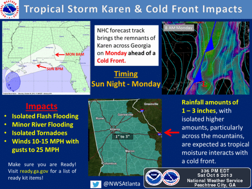
What Will Karen Mean To Us?
Tornadoes not out of the question Late Sunday into Monday
Waitin' On a Women... a song by Brad Paisley, pretty much sums up TS Karen right now. Karen decided to sit and take a break, so she currently isn't moving at all. Motion toward the north is expected to begin later this evening and landfall is still expected early tomorrow morning in Louisiana.
So the question is what does a landfalling Karen mean for our area? Steven Nelson, the Science and Operations Officer for the Atlanta National Weather Service Office, expressed his concern about the possibility of tornadoes late Sunday afternoon through Monday afternoon. Here's his discussion from this afternoon's Area Forecast Discussion.
.SHORT TERM /TONIGHT THROUGH MONDAY/...
PRIMARY FOCUS IN THE SHORT TERM IS TS KAREN AND MORE SPECIFICALLY
ITS INTERACTION OF WHAT WILL BE LEFT OF KAREN WITH FAIRLY STRONG COLD FRONT. KAREN CONTINUES TO WEAKEN AT THIS HOUR. HAVE NOT SEEN ANY BUOY OR SFC OBS IN THE GULF WITH GUSTS OVER 30KTS SO FAR TODAY. LOW LEVEL CENTER EXPOSED IN VIS IMAGERY DUE TO MDT VERTICAL WIND SHEAR. CONVECTION IS DISPLACED ABOUT 50-100MI EAST OF LOW LEVEL CENTER. 12Z MODEL GUIDANCE IN GOOD AGREEMENT ON TAKING REMNANTS OF KAREN NORTH THEN ESSENTIALLY STRAIGHT EAST ACROSS GULF COAST. DUE TO WEAKER CENTER AND WEAKER GRADIENT WITH APPROACHING FRONT... SHOULD SEE LITTLE IF ANY WIND IMPACTS HERE. PERHAPS SOME GUSTS OVER 25 MPH. WILL BE UPDATING GRAPHICS AND DSS TO REFLECT THIS.
AS ALLUDED TO ABOVE... INTERACTION WITH APPROACHING COLD FRONT WILL BE SIGNIFICANT AS RICH MOISTURE POISED TO FLOW NORTH INTO THE STATE AND BE AVAIL FOR MODERATELY STRONG VERTICAL MOTION ASSOC WITH FRONT. FCST PW VALUES FOR SUNDAY AND MONDAY NEAR RECORD VALUES BASED ON 65 YEAR SOUNDING CLIMATOLOGY FOR FFC AND ABOVE 99 PERCENTILE.
BASED ON THIS... HAVE UPPED QPF GUIDANCE SLIGHTLY. STILL WITH
WEAKENING OF KAREN... ONLY GETTING 1-2.5 INCHES OF RAIN FOR THE EVENT. STILL UNCOMFORTABLE GOING LOWER THAN THIS BUT SHIFT IN MODELS HARD TO FIGHT.
SOME CONCERN FOR BRIEF TORNADOES... PERHAPS MORE OF QLCS VARIETY THAN CELLULAR TC TORNADOES. NAM12 MORE AGGRESSIVE WITH PARAMETERS AND WITH RICH LOW LEVEL MOISTURE... CANNOT RULE OUT ISOLD TOR THREAT FROM SUN AFTERNOON THRU MON AFTERNOON. SREF PROB OF SIG TOR PARAMETER > 1.0 ONLY REACHES 10PCT BUT MAXIMIZES 06Z-12Z MONDAY MORNING. WILL CONTINUE WATCHING THIS.
SNELSON
As I mentioned several posts ago, it will come down to the timing between the front and Karen that will determine how the two interact. Tomorrow morning will bring a better picture about how this rain event will unfold, but with unseasonably high PW values of +2" and the interaction of that with a strong cold front, the potential for heavy rainfall is almost certain.
Like what you read here and want to be notified of new posts and updates? You can subscribe to this weather blog by clicking here and then clicking on "Get email updates"Please remember, whenever you need weather information, please visit us at the new and improved DaculaWeather.com. You can also get the latest weather information by following us on Twitter, Facebook, and here on the Patch! DaculaWeather.com... Your Window to the Weather