You didn't know you lived in the tropics did you? If you were thinking sunny, Hot 'lanta is where you live, things have changed, wake up and smell the mold!
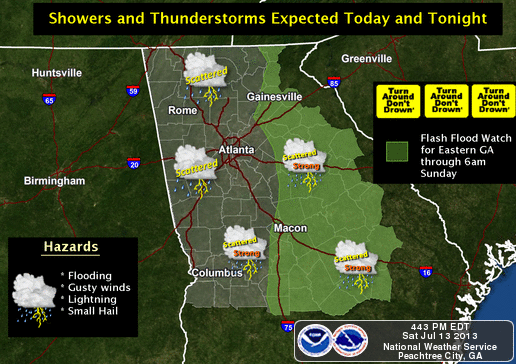
There is some relief in sight (hard to believe I'm talking like that about rain after the last two miserable summers) toward the end of the work week as we get back to a more normal summertime diurnal rain pattern, but not before we get another dose of rain beginning tonight. Barrow, Hall, Jackson, Oconee, and Walton counties have been placed under a Flash Flood Watch once again, and counties to the west (Gwinnett, Fulton, etc) are still susceptible to flash flooding despite no watch.
An upper low that had been sitting over the northeast has begun a rapid retrograde southwest as a strong high pressure system builds in from the Atlantic. This will increase our chances for rainfall as PW values of almost 2" build back in on a southeasterly, then southerly flow as the low moves further west, and for the next day or so, our rain chances increase. It looks like Texas will finally get some much needed rain to help break an extended drought, which has slowly been getting better. As the week goes on, temperatures will also be on the rise as we feel the effects of subsidence from the high pressure to our north and northeast. In this loop, you can see the low move west and dissipate while the strong area of high pressure takes over the east
The Atlanta NWS had this to say this afternoon:
ALTHOUGH MODELS SUGGEST BETTER CHANCES OF RAIN ACROSS NORTH GEORGIA TONIGHT... THE QUESTION IS JUST HOW MUCH RAIN AND WILL IT DWINDLE OVERNIGHT. CONFIDENCE IS LOW ON THE POP FORECAST OVERNIGHT. EVEN WITH THE UPPER LEVEL LOW WELL WEST OF THE CWA TOMORROW... LOW LEVELS REMAIN VERY MOIST WITH EASTERLY FLOW OFF THE ATLANTIC. MODELS ARE STILL SUGGESTING PRECIP ACROSS THE ENTIRE AREA FOR SUNDAY... KEEPING US IN THIS NON-TYPICAL SUMMERTIME PATTERN. HIGH TEMPS FOR SUNDAY ARE FORECAST TO BE WELL BELOW NORMAL WITH THE LOW TO MID 80S ACROSS NORTH GEORGIA AND MID 80S ACROSS CENTRAL GEORGIA.
For the extended part of the week, this discussion:
UPPER LOW MOVING WEST AT THE START OF THE PERIOD WITH STRONG UPPER RIDGE OVER THE NORTHEAST. TROPICAL MOISTURE STILL BEING DRAWN MOVING ACROSS THE CWA AT DURING THE FIRST OF THE WEEK. A DEEP EASTERLY FLOW PATTERN WILL KEEP ATLANTIC MOISTURE OVER THE CWA THROUGH MUCH OF THE PERIOD. THE FLOW BECOMES MORE SOUTHWESTERLY BY THURSDAY INTO FRIDAY AS THE UPPER RIDGE WEAKENS A BIT A SHIFTS SOUTHWARD. IN GENERAL... HAVE BASICALLY KEPT CHANCE POPS EACH DAY WITH SLIGHT CHANCE OVERNIGHT THROUGH THE PERIOD. A DIURNAL PATTERN SHOULD BECOME MORE PROMINENT THROUGH THE WEEK... WITH AFTERNOON TEMPERATURES BECOMING A BIT WARMER.
Please remember, whenever you need weather information, please visit us at the new and improved DaculaWeather.com. You can also get the latest weather information by following us on Twitter, Facebook, and here on the Patch! DaculaWeather.com... Your Window to the Weather