Health & Fitness
Cloudy Dreary Work Week Ahead
In the meantime, polar air from Siberia invades the west central US with lows -20F and wind chills 30-40 degrees below zero


From my buddy Larry:
"FWIW, the 12Z Euro does give a significant to major winter storm to parts of the southeast US 12/12-13 thanks to a very weak Miller A combined with significant CAD. The very weak low is just ESE of Brownsville early on 12/6 and it moves across central FL on 12/13. This is quite far south and is the kind of track that can result in unusually far south significant SE wintry precip.. when the cold air to the north is ample. The QPF is generous (1-1.5" from SW GA to SE NC) which just goes to show that very a lot of precipitation can be associated with very weak Miller A's in the SE US. Many in history were that way.
This Miller A generates sig. to major snow from N GA across C & N SC to S & C NC. Also, due to strong wedging, there appears to be quite a bit of sleet in C and N GA, much of SC,and far southern NC. To the south of this, there appears to be sig. ZR over C and even northern portions of S GA as well as S and C SC. Keep in mind that the Euro has a warm bias at 2 meters when there is sig. evap. cooling."
----------------------------------
UPDATE - Thursday
If you have family and/or friends in North Carolina, they need to take notice:
This is from Allan Hoffman, a meteorologist in Raleigh NC:
-------------------------------------------------------
For those of you that follow me on twitter @RaleighWx you know I have been concerned about ice potential this Sunday for a while now, despite each model cycle oscillation on the exact thermal structure in place.
Find out what's happening in Daculawith free, real-time updates from Patch.
The reason why was that the models have been unanimous in moving a strong 1035-1040mb high into the northeast US Saturday night and creating a strong classical CAD (cold air damming setup) event. This high pressure is associated with a very cold air mass for this time of year so there was no question that the cold/dry air associated with it could be sufficient for an ice event.
The big question was always the timing of the arrival of the cold air and the moisture. Earlier in the week it looked like moisture was going to arrive Saturday night with the cold air associated with the high pressure not filtering in till Saturday night and Sunday not early enough to set up a cold (below freezing) wedge east of the mountains. This scenario would lead to only minor ice or no ice for those south of Virginia as the transport of cold air would not be sufficient and enough.
Find out what's happening in Daculawith free, real-time updates from Patch.
However, recent model trends have shown this cold surface air arriving earlier. And in fact today’s 12z NAM shows it arriving Saturday night with dewpoints in the teens even reaching down into northern NC late Saturday night.
This results in strong evaporational cooling Sunday morning and an entrenched strong surface cold air mass east of the mountains. Moisture overruns this early Sunday morning and we get an icy day Sunday with anywhere from 0.25 to 0.75 inches of QPF falling in the form of mostly freezing rain from prone regions in the mountains to around or just north of Charlotte to Sanford to Rocky Mount and north and west of there including the Triangle. In fact the 12z NAM keeps temps near freezing through at least 7pm Sunday.
The 12z GFS is very similar in overall features but a bit lighter with precip (0.25 to 0.5 inches) and not quite as cold Sunday although close. It keeps the surface freezing line around or just north of the Triangle along the I-40 corridor. However, it could be that the coarse nature of the GFS model compared to the higher resolution of the NAM means the GFS model isn’t resolving the complicated thermal structure in the lower levels correctly. The 12z GGEM is also colder than previous runs and very similar to the NAM in showing a significant ice event Sunday.
The ECMWF trended cooler too but taken literally it does keep the surface freezing line further west and confines ice to the northern foothills.
So what is the bottom line? I think that we will receive a moderate to in some places significant ice event on Sunday during the day. Temperatures will fall Sunday night and increasing drier air at the surface will advect into the area from the NE as the CAD wedge establishes itself. Precipitation will likely break out in the wee hours Sunday morning and begin as rain but quickly change over to freezing rain for areas as far south as the NC/SC border in the foothills/southern piedmont. This will continue into much of NC west of I-95Sunday morning. As winds aloft increase from the SW we will see the warm nose strengthen and slowly the CADS wedge will weaken along the southern/eastern edges with temperatures warming above freezing Sunday morning to lunch time from the southern piedmont (CLT to the NC coastal plain) with perhaps a 0.1 inch of glaze possible. Further north and west including the Triangle, Triad and into the northern foothills the freezing rain will last longer with more significant accumulation. For now I would go with a general 0.25 inch freezing rain glaze for those areas (See map) with likely the usual areas of the Triad to Hickory to getting more than the Triangle. The foothills near the escarpment and the far NW piedmont near the Va border could see damaging ice accrual up to 0.5 inches.
Again see the map for my ideas. The general trend of cooler air arriving earlier and ice being a bigger problem is undeniable the last 24 hours. If the 12z Nam scenario is correct these totals could need to be increased. I will update as needed.
------------------------------------------------------------------------Good morning and welcome to the first day of Winter! :-)
You're probably sitting there thinking, either "this guy is off his rocker", or you're grabbing a calendar and wondering where the month went! But no, you're not crazy. The solar winter, or the winter solstice occurs this year on December 21st, at 12:12pm, but as far as meteorologist are concerned, winter starts December 1 and runs through the end of February, so it's officially wintertime!
We had some very cold days in November (I hit 19.3F for the monthly low), This was the coldest November (47.6F avg), by two degrees, since I've been keeping records since 2008. And it was 4.7 degrees colder than November 2009, which was the warmest during the 2008-2013 period.
The atmosphere has been taking a little break before it becomes very active again this upcoming week. This time will be a little different than the last bout of weather we had, in that our temperatures will start off about normal but slowly rise to about 10 degrees above normal by Friday. We are currently in a fast zonal flow where our systems move very quickly from west to east, with lots of overrunning moisture in the upper levels, and we'll have small impulses of energy from the Pacific traveling with the flow, bringing clouds and small chances for precipitation throughout the week.
If you read my past blog post, you may remember me talking about the NAO/AO teleconnection indices and how they help to determine our winter weather here. Right now, both the NAO and AO are positive, which is not conducive for winter weather in our area, hence the mild conditions we're experiencing right now. Because the ENSO is relatively neutral right now, the NAO/AO blocking patterns will become much more important in determining how our winter weather plays out, and whether we get cold or stay mild. A positive state for both of these indices generally means no blocking, and we get into a zonal flow like what we're in right now.
The models have been hinting at an overrunning icing event next week in the mid-section of the country with some very cold dense air pushing south. More rain is pushed out ahead of the next cold front next weekend, and heavy rain may be a part of our forecast once again. The Weather Prediction Center discussed the precip and cold air in their extended discussion:
"THIS FLOW FAVORS N-CENTRAL US CYCLOGENSIS WED/THU THAT AIDS DOWNSTREAM ENHANCEMENT OF LEAD WARM/MOIST AIR ADVECTION AND FOCUS FOR MODEST TO LOCALLY HEAVY TRAILING FRONTAL QPF WITH MAX SUPPORT LIKELY CENTERED OVER THE E-CENTRAL US WARM SECTOR, WITH DEEPER INFLUX OF GULF MOISTURE LATE WEEK ALONG WITH A EARLIER PERIOD THREAT CLOSER TO THE LOW FOR SIGNIFICANT WRAPBACK NRN PLAINS/UPPER MIDWEST TO GREAT LAKE SNOWS AS THE MAIN LOW HEADS EJECTS NEWD TOWARD E-CENTRAL CANADA BY LATE WEEK. FIERCE COLD AIR WILL MEANWHILE PLUNGE DOWN THROUGH THE PLAINS AND SPREAD SOUTH AND EAST IN THE WAKE OF SYSTEM PASSAGE."
The Bismark North Dakota NWS forecast office is warning residents of the impending winter storm, particularly the bitterly cold temps and wind chills:
"ADDITIONAL WINTER WEATHER HEADLINES FOR WIND CHILLS WILL LIKELY BE NEEDED THURSDAY AND INTO THE WEEKEND AS ARCTIC AIR TAKES UP RESIDENCE ACROSS THE NORTHERN PLAINS. FORECAST HIGHS THURSDAY THROUGH SUNDAY ARE IN THE SINGLE DIGITS ABOVE OR BELOW ALONG WITH NIGHTTIME LOWS SUBZERO... POSSIBLY COLDER THAN 20 BELOW. RESULTANT WIND CHILLS WILL EASILY RANGE 20-30 BELOW... WITH 45 BELOW VALUES CURRENTLY FORECAST NORTH CENTRAL FRIDAY NIGHT. "
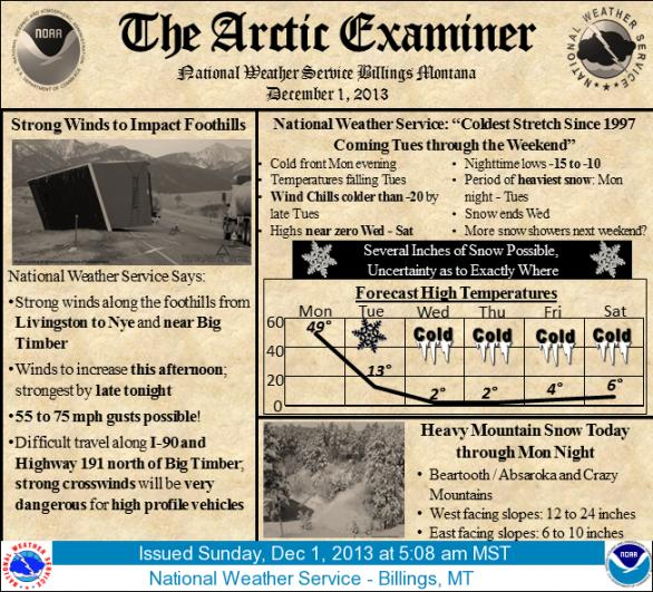
Wouldn't you just love to see this forecast from North Dakota here? I was browsing the images on the Western Region NWS Summary page and found this image today, very creative! This is their forecast discussion.
No cold outbreaks here for a little while, but we will be cloudy and rather dreary for at least a week beginning later tonight, don't get too depressed! :-)
--------------------------------------------------------------------------
Like what you read here and want to be notified of new posts and updates?
You can subscribe to this weather blog by clicking here and then clicking on "Get email updates"
You can also get the latest weather information by following us on:
DaculaWeather.com... Your Window to the Weather